What is the distance between the Earth's surface and the motorists' satnav satellites?
-
$\begingroup$ From celestrak.com, you can get TLE file any unclassified satellite. Placing that TLE information into satellite-calculations.com will give you many information including the one you seek for. $\endgroup$– VolkanOzcanCommented Mar 9, 2017 at 11:06
2 Answers
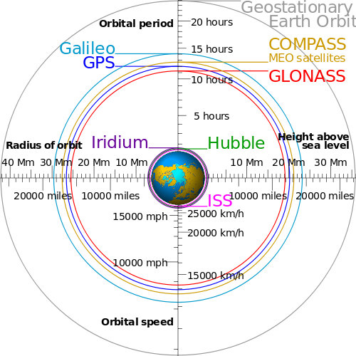
For satellite navigation, you are most likely using the Global Positioning System, which uses six planes of satellites at an altitude of 20,180 km. However, many systems can also use the GLONASS satellite constellation to get more satellites visible, especially near the poles. They orbit in three planes at 19,130 km.
The less complete systems BeiDou and Galileo use satellites at 21,150 km and 23,222 km respectively.
You can get a real-time view of some of the constellations at stuffin.space
GPS satellites orbit at an altitude of about 12,550 miles.
However, as GPS is controlled by the US Department of Defense, who can (theoretically) turn it off whenever they want there are various other navigation systems:
- Glonass (Russian). This is in a highly elliptical orbit, so "altitude" is not constant.
- Beidou (China). This constellation utilizes satellites at a number of radically different altitudes.
- Galileo (Europe). These are in a similar, though not identical, orbit to GPS.
Some hand-held satnavs can use multiple satellite systems. I have a Garmin cycle computer that can use both GPS and Glonass.
-
1$\begingroup$ Do you have a reference for your assertion that Glonass uses a highly elliptical orbit? Online references such as navipedia and wikipedia state that they are circular. $\endgroup$ Commented Mar 9, 2017 at 13:24
-
1$\begingroup$ It looks like about half of this is wrong information. Also "highly elliptical" and "radically different" aren't helpful phrases for a technical answer. Take a look at this answer GPS satellites have an orbital period of 1/2 day, and "It should be noted that every other GNSS system that has been launched uses a similar orbit to GPS. GLONASS is 8/17 of a day, BeiDou 9/17, and Galileo is 10/17." $\endgroup$– uhohCommented Mar 9, 2017 at 13:58
-
$\begingroup$ AFAIK supporting all the constellations is less about worrying that one might get turned off than it is about improving performance in areas with restricted lines of sight by being able to get eg a 4 sat fix with 2xGPS 1xGLONAS, and 1xBeidou instead of failing because it can only get 2xGPS. Also a single global chip is simpler logistically than GPS only models for the US, GLONAS only for Russia, and Beidou only for China. (AFAIK Galileo doesn't have enough up to give complete coverage anywhere yet.) $\endgroup$ Commented Mar 9, 2017 at 16:34
-
$\begingroup$ @DanNeely Another consideration, applying to phones is power consumption. Although having both GPS and GLONASS chips is pretty common, they are usually not used at the same time. $\endgroup$ Commented Mar 9, 2017 at 17:06
-
$\begingroup$ If wiki is to be believed then glonass will be using elliptical orbits in the future, so Neil has a point even if it isnt true yet en.wikipedia.org/wiki/Molniya_orbit $\endgroup$ Commented Mar 9, 2017 at 18:59
