Will they really be able to “see” OSIRIS-REx from Australia? With meteor cameras?
Yes, we were!
For all those who are interested, here is the preprint of the paper that resulted from the observations and is currently in review. Along with a conference abstract from AMOS 2018.
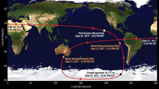
Optical tracking systems typically trade-off between astrometric precision and field-of-view. In this work, we showcase a networked approach to optical tracking using very wide field-of-view imagers that have relatively low astrometric precision on the scheduled OSIRIS-REx slingshot manoeuvre around Earth on September 22nd, 2017. As part of a trajectory designed to get OSIRIS-REx to NEO 101955 Bennu, this flyby event was viewed from 13 remote sensors spread across Australia and New Zealand to promote triangulatable observations. Each observatory in this portable network was constructed to be as lightweight and portable as possible, with hardware based off the successful design of the Desert Fireball Network.
Over a 4 hour collection window, we gathered 15,439 images of the night
sky in the predicted direction of the OSIRIS-REx spacecraft. Using a specially developed streak detection and orbit determination data pipeline, we detected 2,090 line-of-sight observations. Our fitted orbit was determined to be within about 10 km of orbital telemetry along the observed 109,262 km length of OSIRIS-REx trajectory, and thus demonstrating the impressive capability of a networked approach to SSA.
OSIRIS-REx is a NASA sample-return mission to asteroid Bennu. On 22nd September 2017 it performed an Earth gravity-assist (EGA) manoeuvre with favourable viewing opportunities from Australia. The closest approach occurred over Antarctica and it passed over Australia with an altitude of 42,000 – 73,000km. The FireOPAL team built an Australia-wide observation campaign around the EGA. Observers flew to 11 sites around Australia, and one in New Zealand, to take observations. The distribution of sites was chosen to maximise opportunities for triangulation. Approximately 2,000 images of the spacecraft were acquired from each site as it transited over Australia & New Zealand. This dataset, for a single object on a single pass, is unprecedented. It enables us to perform a detailed evaluation of position / range errors for triangulated observations. In addition, lightcurve information from multiple viewing angles for a target of known size and composition allows us to evaluate the degree to which target geometry can be reconstructed from lightcurves.
