12
$\begingroup$

I've just been reading about the Apollo program.

Apollo 8 seems to have gone into a fairly circular lunar orbit 69 miles at perigee.

Apollo 10 was pretty much similar, although they dipped down with the "Snoopy" lunar module.

Apollo 11 dropped into that sort of orbit (LOI-2 after LOI-1) and the CSM (Command/Service Module) stayed in it.

The Apollo 11 LM (Lunar Module) orbited the Moon 31 times before it landed, and I read a few days ago in a book that at its lowest its perigree was about 7 miles (I haven't been able to find any precise corroboration on that just searching). I presume that perigee will have been set to coincide with the Sea of Tranquillity, on the visible side of the Moon, so no doubt the apogee on the hidden side will have been higher. But how much? That will depend on how elliptical that orbit was.

After the moon landing the LM ascent stage went into a "highly elliptical" orbit which I read was "18km (perigee) x 87km (apogee)" before being able to dock with the CSM.

It is amazing to think of it, but I believe it is the case that before Apollo 8 no-one had seen anything of the hidden side of the Moon, ever. I believe that an uncrewed Soviet craft went there in 1967/68, but I don't think it took any photos for example.

So there were the astronauts of Apollo 8 and Apollo 10 who were able to observe the hidden side of the Moon during quite short missions ... and then Apollo 11 LM, where it was assumed that a 7-mile perigee was sufficiently high to pose no risk of crashing into a Lunar mountain. It is also emphasised in this book that on the hidden side of the Moon, if the Sun is behind it, you see absolutely nothing of the surface unless there is some Earthshine. So I don't know how much the crews of the fairly short Apollo 8 and 10 missions will have seen.

But supposing the Moon's hidden hemisphere had been all corrugated and not spherical at all? Supposing there had been enormous mountain ranges rising 20 or more miles above the predicted spherical surface?

Were they just relying on the observations made by Apollo 8 and 10? Or was there more to it than that? Were there other reasons to believe that the hidden side of the Moon was essentially spherical?
$\endgroup$
6
  • $\begingroup$ in fact 7 miles is pretty much the height of the higest point on the moon en.wikipedia.org/wiki/Selenean_summit $\endgroup$ Commented Sep 30, 2023 at 17:00
  • 19
    $\begingroup$ Your assumption about the far side being unknown is incorrect. 99% of the Moon was mapped by the Lunar Orbiter program before the crews landed. en.wikipedia.org/wiki/Lunar_Orbiter_program $\endgroup$ Commented Sep 30, 2023 at 17:38
  • 8
    $\begingroup$ The Soviet Luna 3 probe sent back photos of the far side of the moon in 1959. $\endgroup$
    – Seth R
    Commented Oct 1, 2023 at 2:52
  • $\begingroup$ Comments have been moved to chat; please do not continue the discussion here. Before posting a comment below this one, please review the purposes of comments. Comments that do not request clarification or suggest improvements usually belong as an answer, on Space Exploration Meta, or in Space Exploration Chat. Comments continuing discussion may be removed. $\endgroup$
    – Rory Alsop
    Commented Oct 3, 2023 at 17:32
  • $\begingroup$ @mikerodent - we expect folks here to be nice. Please read the tour and How to Ask pages to refresh your understanding of our rules. $\endgroup$
    – Rory Alsop
    Commented Oct 3, 2023 at 17:33

3 Answers 3

39
$\begingroup$

Edit: I'm going to have to retract part of my answer. The 1967 farside maps made from Lunar Orbiter data show no elevation information.

By the time of Apollo 8, the Lunar Orbiter program had mapped 99% of the lunar surface, including the far side. This had an accuracy of 60 meters/pixel or better, and they took oblique photos that would allow altitudes to be measured. I haven't been able to find if this was done: the lack of elevation data on the farside maps indicates this was not done for the whole surface.

To find out what we knew about lunar elevations, I looked at this list of maps of the Moon.

This map from 1966 shows that some elevation data was available before Apollo. This map was made from photos taken by several telescopes on Earth.

The relative elevations ... were determined by the shadow measuring techniques as refined by the Department of Astronomy, Manchester University, under the direction of Professor Zdeněk Kopal.

Apollo missions 15-17 carried the Apollo Panoramic Camera (APC). This was a stereo camera, which allowed more accurate altitude measurements. Earlier missions also did stereophotography, but this seems to have been less systematic.

Apollo 15 and 16 carried a laser altimeter.

$\endgroup$
3
  • 1
    $\begingroup$ Amazing. I'd never heard of it, or if I did it'd gone in one ear and out the other. So they weren't just hoping for the best. $\endgroup$ Commented Sep 30, 2023 at 17:44
  • $\begingroup$ To map the surface you only have to take a few photos. To accurately measure mountain heights with oblique photos, wouldn’t you need a whole lot of them? Plus some way to know distance from the Moon’s CoG. $\endgroup$
    – Michael
    Commented Oct 1, 2023 at 16:09
  • 12
    $\begingroup$ @mikerodent very little in the Apollo program was left to "hoping for the best". They gathered as much data and ran every experiment they could think of. The entire Gemini program was pretty much about trying to figure out if a moon landing was something they could pull off. $\endgroup$
    – Seth R
    Commented Oct 1, 2023 at 16:09
28
$\begingroup$

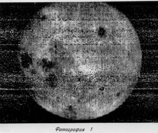
As mentioned in this answer, the far side of the Moon was not unknown by the time of Apollo 11. And in fact the early Soviet probes did send back photos. The first ever view of the lunar far side was from Luna 3 in October 1959, almost exactly two years after Sputnik.

Luna 3
Lunar far side, Luna 3, October 1959 (NASA NDDC archive)

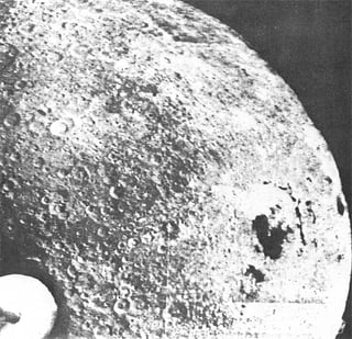
In 1965 Zond 3 filled in the 20% gap missed by Luna 3

Zond 3, July 1965
Lunar far side, Zond 3, July 1965 (NASA History Division

As mentioned in the NASA History Division article:

With this Zond III photography and that of the earlier Luna III, only an area at the south polar region of the far side of the Moon remained to be viewed


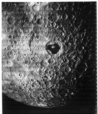
Detailed observations of the entire Moon including the far side occurred during the five Lunar Orbiter Program missions in 1966 and 1967.

Lunar Orbiter 3
Lunar far side, Lunar Orbiter 3, February 1967 (Lunar and Planetary Institute)

According to the Wikipedia article about the Lunar Orbiter program:

99 percent of the lunar surface was mapped from photographs taken with a resolution of 60 meters (200 ft) or better.


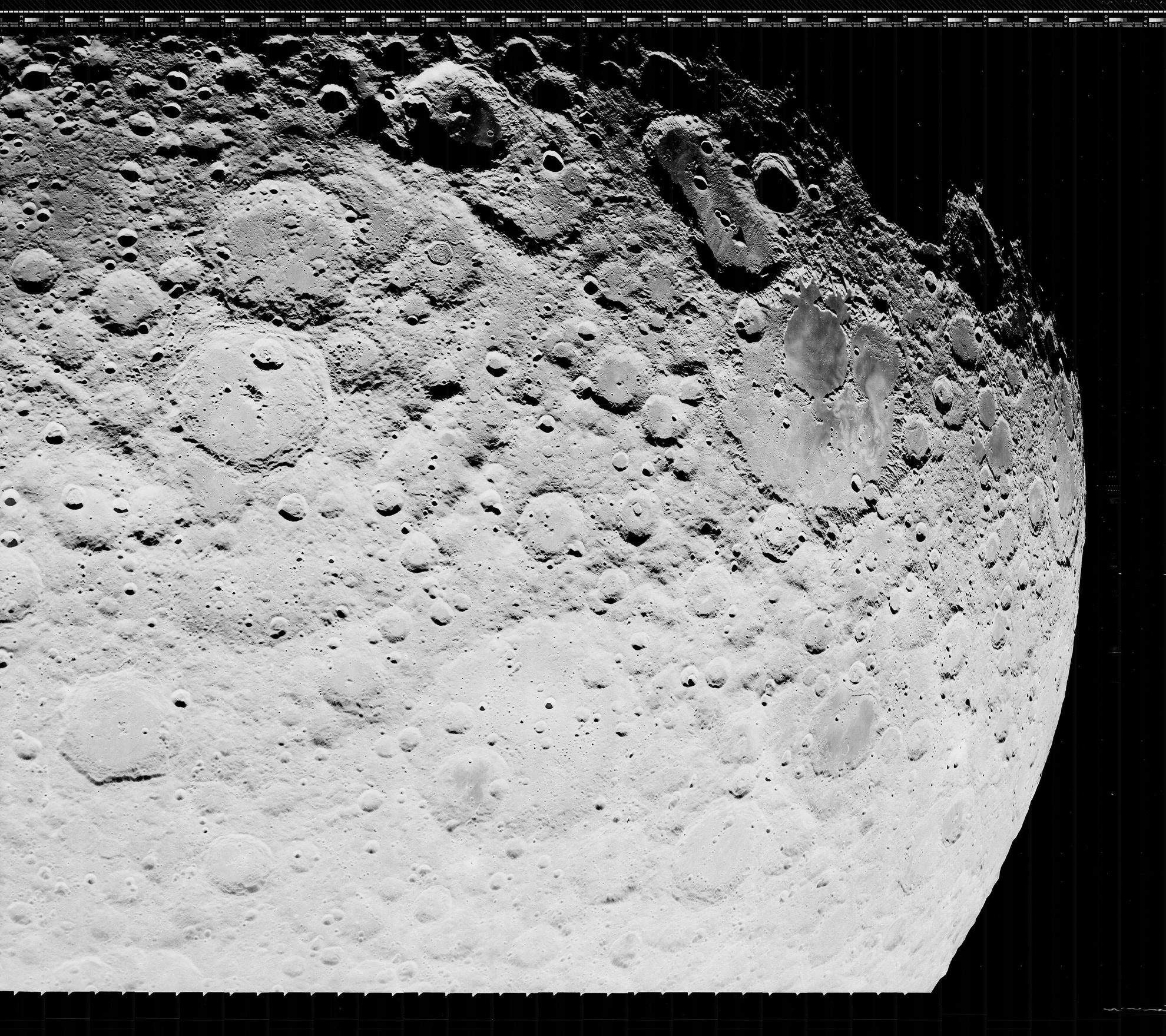
In 2007 Dennis Wingo and NASA Watch founder Keith Cowing helped to restart a previously cancelled program to use modern technology to process the data from the original Lunar Orbiter program tapes, which had nearly been thrown out after being digitized several years earlier. Wingo managed to obtain one of the few refrigerator sized Ampex tape drives still in existence that could get the raw data off of the tapes. The Lunar Orbiter Image Recovery Project was able to successfully restore the images in much higher detail than the original digitization, as seen in this restored image of the lunar far side:

LOIRP Lunar far side, Lunar Orbiter 2, November 1966 (National Archives)

So in reality even more data about the far side of the Moon existed prior to Apollo 11, however the technical ability to use the full amount of data received from the orbiters didn't exist yet.

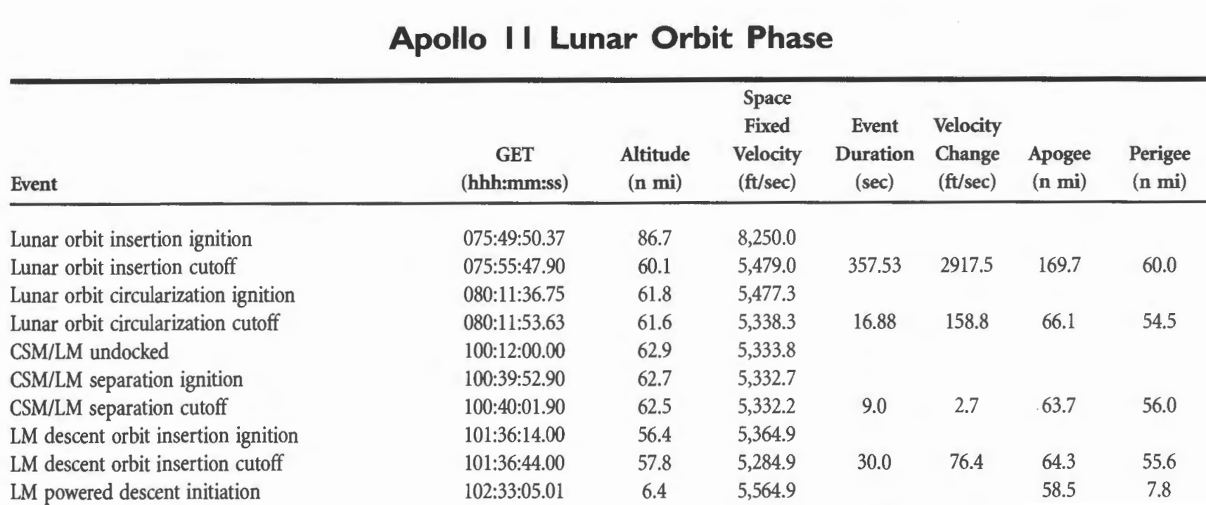
As for the low point in the Apollo 11 lunar module orbit, it had a perigee of 7.8 nautical miles (9 miles, 14 km), as seen in Apollo by the Numbers:

Apollo 11 perigee

Note that perigee is measured above the mean radius, also known as the lunar reference sphere, which is the equivalent of mean sea level on Earth. Perigee does not indicate the actual altitude above the surface since the terrain altitude varies quite a bit. As the table indicates, at powered descent the Apollo 11 lunar module was at an altitude of 6.4 nautical miles (7.4 miles, 12 km) above the surface.

The Apollo 10 lunar module had an 8.5 nautical mile perigee. Its lowest altitude above the surface was 7.8 nautical miles.

Apollo 10 perigee

$\endgroup$
4
  • 4
    $\begingroup$ Re "So in reality even more data about the far side of the Moon existed prior to Apollo 11, however the technical ability to use the full amount of data received from the orbiters didn't exist yet." This may be a bit too philosophical, but I'd say that if you aren't able to retrieve/use the data then you don't really have that data in the first place. Otherwise you might say even more data was available prior to the probes because the moon was already there, they just didn't have the technical ability to get it that data. $\endgroup$
    – user52271
    Commented Oct 1, 2023 at 4:37
  • 10
    $\begingroup$ From what I have read the Lunar Orbiters recorded data onto 70mm film with 1:1000 dynamic range. The orbiters then processed the film, scanned it, then sent it back to Earth. The image data that came in was scanned onto 35mm film in a process not unlike kinescope. The resulting images only had a dynamic range of 1:250, but it was good enough for the purposes of Apollo. Prints were made from the 35mm film and used for planning and astronaut training. The 35mm film was later digitized for archiving. The LOIRP project recovered the raw image data in nearly its original 1:1000 dynamic range. $\endgroup$ Commented Oct 1, 2023 at 13:11
  • 4
    $\begingroup$ @user52271 - Data always goes through a process of retrieval, transport, processing, analysis, utilization. To say that data doesn't exist until it reaches the latter phases of that process seems like a pretty abstract view of data. When the Rosetta Stone was discovered in 1799, prints and plasters were made from the stone and were sent to scholars in Europe, but it would be a couple of decades before they were able to decipher all of it, the last one being the hieroglyphics. Did the hieroglyphics data not exist in Europe until they were able to utilize it? $\endgroup$ Commented Oct 3, 2023 at 3:00
  • $\begingroup$ Champollion was pretty fast, he got the first copy in 1808 and presented his research in 1822. He needed much less time than a couple of decades, only 14 years. He died in 1832. What an exceptional man. $\endgroup$
    – Uwe
    Commented Oct 6, 2023 at 10:55
6
$\begingroup$

NASA contracted the calculations for Apollo lunar orbits out to the same Bellcomm team that determined the landing sites, famously led by Farouk El-Baz. Their methods and results were detailed in the entire May-June 1972 issue of the Bell System Technical Journal volume 51 number 5 (30 Mb pdf, 176 pages).

All of your questions are answered in great detail in Appendix C ("Lunar Orbital Navigation", pages 1080-1090) of that document. I will attempt to summarize here.

Indeed, the moon's gravitational field (not necessarily the sphericity) was known to be an issue with the lunar orbit:

The two largest navigation error sources arose from an incomplete mathematical model of the lunar gravity field and from unmeasured spacecraft propulsive thrusts. Both of these error sources degraded the quality of navigation data extrapolations.

p. 1081

As mentioned in other answers, previous spacecraft in the Lunar Orbiter program collected data that was used to develop a mathematical model of the lunar gravitational field:

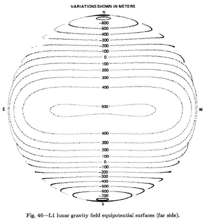
A simple gravitational model, the L1 field, was developed by NASA's Langley Research Center in support of the Apollo program. This model consisted of five harmonic coefficients determined from the Lunar Orbiter satellites and some of the early Apollo data. The coefficients comprising the L1 field are given in Table II.

p. 1083

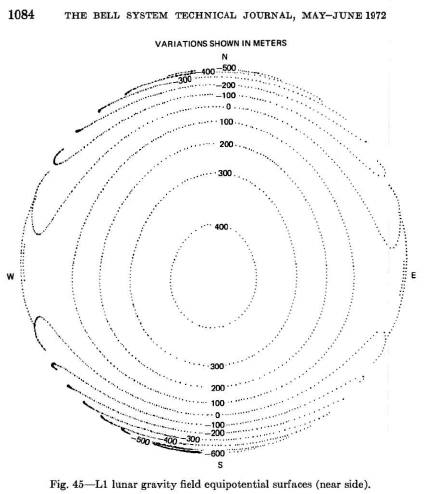
They mapped out the gravitational field of both the near and far sides of the moon:

lunar near side gravity field

lunar far side gravity field

They used these models in computer simulations of orbiting the moon. In practice, they found the best results for landing the lunar module in a precise spot were obtained by monitoring that particular spacecraft while in orbit using radio ranging with Earth stations. They also had the crew measure landmarks on the moon with the on-board telescope.

Your question seems to assume that Apollo 11 was the most critical mission for precision landing. Actually, the mission that required the most precise landing was Apollo 12, which needed to land near Surveyor III in order to recover it. Indeed, the cited article goes in depth about the planning of 12. All of the other missions (including 11) had much more generous landing ellipses. (Yes, there was a boulder field at the 11 landing site, but that was not visible from orbit and was therefore not planned for.)

$\endgroup$
0

Your Answer

By clicking “Post Your Answer”, you agree to our terms of service and acknowledge you have read our privacy policy.

Not the answer you're looking for? Browse other questions tagged or ask your own question.