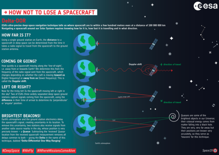
Partial answer...
Considering:
https://www.sciencedaily.com/releases/2018/01/180111223914.htm
NASA engineers has demonstrated fully autonomous X-ray navigation in space
NICER/SEXTANT
https://www.asterlabs.com/publications/2006/Sheikh_et_al,_AIAA_JGCD_Jan_Feb_2006.pdf
Spacecraft Navigation Using X-Ray Pulsars
China's XPNAV 1
Is NICER/SEXTANT the first civilian "spacecraft" to determine it's own position in space without GPS or uplinked data?
How can spacecraft navigate without contact from Earth?
Satellite Position
https://ntrs.nasa.gov/citations/20190000639
Predicted Performance of an X-Ray Navigation System for Future Deep Space and Lunar Missions
https://physicsworld.com/a/x-ray-pulsars-plot-the-way-for-deep-space-gps/
X-ray pulsars plot the way for deep-space GPS
https://www.wired.com/story/nasa-just-proved-it-can-navigate-space-using-pulsars-where-to-now/
NASA Just Proved It Can Navigate Space Using Pulsars. Where to Now?
https://arxiv.org/ftp/arxiv/papers/1704/1704.03316.pdf
Pulsar Positioning System
I had erroneously assumed that JWST would make use of XNAV. But no.
Maybe, probably, due to the time when the project was first started and the length of time it took to get to launch, XNAV probably wasn't matured enough to get on board.
So instead there is this:
Navigation Concepts for the James Webb Space Telescope
https://ntrs.nasa.gov/citations/20040082113
The Mission Engineering and Systems Analysis Division at the Goddard Space Flight Center (GSFC) is supporting the JWST project by developing navigation concepts that meet nominal orbit determination accuracy requirements on the order of 50 km in position and 20 millimeters per second (mm/s) in velocity (3-sigma).
These requirements are challenging because of the unusually large solar radiation pressure (SRP) forces that will be experienced by the spacecraft and the frequent attitude reorientations and unbalanced momentum unloads that are planned for this mission.
This paper evaluates ... approaches for meeting the navigation requirements:
- Ground navigation using standard range and/or Doppler measurements from the Deep Space Network (DSN), which is the current mission baseline
- Onboard navigation using the communications hardware and Sun sensor baselined for this mission
- Onboard navigation using optical celestial navigation sensors that can measure the angle between the Earth and the Moon or a star and the Moon.
The ground navigation approach processes standard range and Doppler measurements from the Deep Space Network.
The onboard navigation approach processes celestial object measurements and/or ground-to-spacecraft Doppler measurements to autonomously estimate the spacecraft’s position and velocity and Doppler reference frequency.
The ground navigation approach provides stable navigation solutions using a tracking schedule of one 30-minute contact per day.
The onboard navigation approach that uses only optical quality celestial object measurements provides stable autonomous navigation solutions.
So, the answer seems to be a combined ground and onboard navigation approach making use of the DSN.
..and not GNSS
So, whilst celestial GPS via Pulsars seems to be the way forward, they do not seem to be on JWST..
Further:
https://www.esa.int/Enabling_Support/Preparing_for_the_Future/Discovery_and_Preparation/Deep_space_communication_and_navigation
https://journals.sagepub.com/doi/pdf/10.1177/002029400804100302
For near-earth space explorers, a variety of autonomous navigation methods have been proposed and explored, including a magnetometer-based
navigation method, Global Position System (GPS), inter-satellite
link, and celestial navigation method.
However, for deep space explorers, celestial navigation is the only feasible way.
