1
$\begingroup$

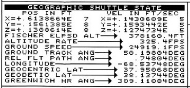
The image below is cropped from https://i.sstatic.net/4XFaJ.jpg as described in this answer. It shows a geographic state of a space shuttle at a given instant in time.

There is only one value for Longitude, but two values for latitude:

  • geocentric latitude
  • geodetic latitude

I'm not asking for a handwaving explanation of the difference, I'd like to know, given that the Earth is not a sphere, nor an ellipsoid, but a lumpy thing:

  1. How were these two quantities defined mathematically
  2. With a geocentric location $X, Y, Z$ and a longitude as given, how were the two kinds of latitudes calculated? What equation was used?

A possibly helpful starting point might be some aspects of this answer. to a question about GPS coordinates.

enter image description here

$\endgroup$
5

1 Answer 1

4
$\begingroup$

Given either geocentric latitude, longitude, and radius or geodetic latitude, longitude, and altitude, the computation of Earth-centered, Earth-fixed cartesian coordinates is fairly simple. For geocentric coordinates $R,\theta,\lambda$, one uses $$ \begin{aligned} R\ &\text{is the radial distance from the center of the Earth} \\ \theta\ &\text{is the geocentric latitude} \\ \lambda\ &\text{is the longitude} \\ \\ x &= R \cos\theta \cos\lambda \\ y &= R \cos\theta \sin\lambda \\ z &= R \sin\theta \end{aligned} $$ It's a bit more complex with geodetic coordinates $h, \phi, \lambda$, but still straightforward (equation 1): $$ \begin{aligned} h\ &\text{is the altitude above some reference ellipsoid} \\ \phi\ &\text{is the geodetic latitude} \\ \lambda\ &\text{is the longitude} \\ a\ &\text{is the equatorial radius of that reference ellipsoid} \\ e\ &\text{is the eccentricity of that reference ellipsoid} \\ \\ N\ &\text{is the radius of curvature of the reference ellipsoid at the subsatellite point:} \\ N &= \frac{a}{1-e^2\sin^2\phi} \\ \\ x &= (N+h) \cos\phi \cos\lambda \\ y &= (N+h) \cos\phi \sin\lambda \\ z &= (N(1-e^2)+h) \sin\phi \end{aligned} $$

What about the reverse problem, computing geocentric or geodetic coordinates given Earth-centered, Earth-fixed cartesian coordinates? Geocentric is easy: $$\begin{aligned} r^2 &= x^2 + y^2 \\ R^2 &= r^2 + z^2 \\ \tan \theta &= \frac z r \\ \tan \lambda &= \frac y x \end{aligned} $$ Geodetic coordinates for points known to be on the reference ellipsoid is also easy: $$\begin{aligned} r^2 &= x^2 + y^2 \\ h &= 0 \\ \tan \phi &= \frac z{r(1-e^2)} \\ \tan \lambda &= \frac y x \end{aligned} $$

But what about points that are not on the reference ellipsoid? This involves solving equation (1) for $h$, $\phi$, and $\lambda$ given $x$, $y$, and $z$. This is a transcendental hot mess. A large number of papers have been published on how to accomplish this, all involving either iteration or approximation, which are the only choices when faced with a transcendental hot mess. A small sampling of the many papers published on this topic:

K. M. Borkowski, “Accurate algorithms to transform geocentric to geodetic coordinates,” Bulletin Géodésique, 63.1 50–56 (1989).

T. Fukushima, “Fast transform from geocentric to geodetic coordinates,” Journal of Geodesy 73.11 603-610 (1999).

M. Ligas and P. Banasik, “Conversion between Cartesian and geodetic coordinates on a rotational ellipsoid by solving a system of nonlinear equations,” Geodesy and Cartography 60.2 145-159 (2011).

P. Civicioglu, “Transforming geocentric cartesian coordinates to geodetic coordinates by using differential search algorithm,” Computers & Geosciences 46 229-247 (2012).
$\endgroup$
7
  • $\begingroup$ For geocentric latitude you are using a simple sphere. I thought it should be the latitude of the point where the shuttle-geocenter line intersects the ellipsoid. For [0.6138664E+07, -0.1561385E+08, +0.1308614E+08] feet I get 37.95402 degrees for geocentric latitude using your equations, but the image shows 37.95068 degrees. It's a small difference (about 400 meters) so I wonder if that's more of an update lag of the display than a sphere vs ellipsoid thing. I'm won't be able to go through this completely until the weekend, but thanks for the thorough answer! $\endgroup$
    – uhoh
    Commented Apr 19, 2019 at 14:50
  • 2
    $\begingroup$ @uhoh - What I wrote is the extremely standard definition of geocentric latitude. Any other definition would be highly nonstandard. There are number of possible explanations of this apparent discrepancy. (1) The SMS may have used single precision rather than double precision for some of the calculations. (2) Someone wrote $\pi$ as 3.14189 as opposed to 3.14159. (3) (Most likely) The screenshot values represent values from slightly different points in time. $\endgroup$ Commented Apr 19, 2019 at 15:44
  • 1
    $\begingroup$ @uhoh - That document does not discuss geocentric latitude at all. Both referenced figures refer to geodetic latitude, not geocentric. That document's expressions for geodetic latitude and longitude (their equations 2-1 and 2-2) are the same as my equation (1), with two slight differences: They use $a_F$ rather than $N$, and use flattening ($F$ in that document) rather then eccentricity ($e$ in my answer). The relationship between flattening and eccentricity is $e^2 = 2F-F^2$, or $(1-F)^2 = 1-e^2$. Thus their equations 2-1 and 2-2 and my equation (1) are equivalent. $\endgroup$ Commented Apr 21, 2019 at 8:18
  • 1
    $\begingroup$ @uhoh - I don't know where you obtained the figure to which you linked in you last comment, but it doesn't come from the document to which you linked. All I can say is that that is a highly non-standard definition of the geocentric latitude of a satellite. And a rather useless one, IIMHO. $\endgroup$ Commented Apr 21, 2019 at 8:29
  • 1
    $\begingroup$ @DavidHammen I expect you are right about the time skew. The "parameter EOM" (that calculated things like lat and lon) ran in a slow "frame job", relatively few times per second. The "Translational EOM" that calculated the positions ran as fast as the mainframe would allow (25 times/sec). Pretty sure we got pi right. Also, the geodetic calculations did use an iterative method since the "truth" location was in M50 coordinates. From what I remember, anyway. $\endgroup$ Commented Apr 23, 2019 at 1:00

Your Answer

By clicking “Post Your Answer”, you agree to our terms of service and acknowledge you have read our privacy policy.

Not the answer you're looking for? Browse other questions tagged or ask your own question.