5
$\begingroup$

Apologies if this has been asked before using terminology for somebody more familiar with the subject matter. I've searched but cannot find an answer.

Assuming space travel was possible (to other galaxies way beyond ours, for example), how would the location of Earth be represented so that pilots could find their way back? Or another example, to describe how to find Earth to passing craft in interstellar travel?

I'm thinking that technologies like GPS use satellities with the Earth itself as an abolute object to calculate from. In space, Earth obviously has to be "located" within a wider scope.

$\endgroup$
2
  • $\begingroup$ Related: AstronomyCast podcasts 413 and 414: Navigating Near and Navigating Far $\endgroup$
    – user10509
    Commented Jul 24, 2017 at 19:04
  • 1
    $\begingroup$ You might be interested in How to determine one's position in space? on Worldbuilding. While that question posits faster-than-light travel, as far as I can see none of the proposed solutions necessarily involve any FTL. $\endgroup$
    – user
    Commented Jul 26, 2017 at 11:14

5 Answers 5

13
$\begingroup$

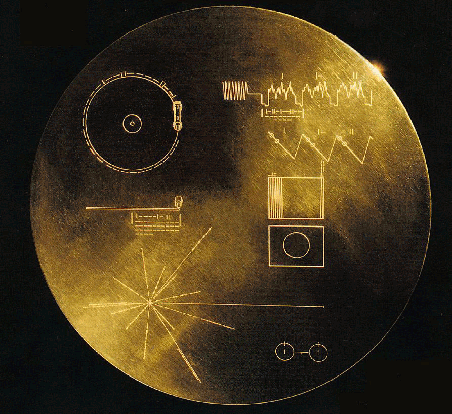
Like the lower left part of the image below.

enter image description here

Define a set of pulsars through describing proportions between their frequencies. Define distances from each of them. This uniquely identifies a point in space, and the pulsars are very efficient "beacons" recognizable from very far.

This would determine position of Sun. As for Earth, third planet, easy.

$\endgroup$
5
$\begingroup$

I suspect that navigating to a galaxy would be done by knowing the characteristics of the galaxy. There are a few ways to do so, but depending on the orbital resolution, the shape, pulsar characteristics, center of the galaxy black hole characteristics, or even more generic items like this Wikipedia article hints at would characterize a galaxy. This would work for relatively far away to identify the Milky Way.

Within a galaxy the problem is much easier. Pulsars have a unique frequency, and there are enough of them that one can use them to find where one is in space, and as a result, where Earth is. Essentially you take a hundred of these markers, and plot the angles vs each other, run through a linear solver to determine where you are. I suspect the practical accuracy of these is such that once you have used them, you can find where the Sun is close enough to send a ship there and spot Earth through visual means.

$\endgroup$
2
$\begingroup$

Earth navigation involves two determinations of location: location of your destination and your current location.

To determine location you need a coordinate system. The coordinate system we made up for Earth navigation uses latitude and longitude. The origin of Earth latitude is set at the equator while the origin of Earth longitude is set at Greenwich observatory in the UK. Space travel will likely involve some similar made up origin system, depending on the scale of the travel. For interplanetary spaceflight, NASA uses several different coordinate systems described here Interstellar spaceflight, travel within the galaxy, may use the same galactic coordinate system that astronomers use, or it may use an adjusted coordinate system with the galactic center as the origin. Likewise, intergalactic spaceflight, may use the supergalactic coordinate system that astronomers use, or it may use a modified version.

When we navigate on Earth, the locations of most destinations are determined using search software, we really only look up GPS coordinates ourselves and enter them into our GPS if the destination is unnamed. Determination of the location of destinations in long-distance spaceflight will likely be similar. A destination will be entered into the navigation computer, which will find the location in its database.

Earth-orbiting satellites often use star trackers to determine the satellite's orientation (attitude). It's possible interstellar spacecraft will be equipped with telescopes and computers that determine location based on the arrangement of stars in our galaxy and other galaxies.

Whatever the coordinate system, spaceflight navigation will require more information than GPS systems. On Earth, coordinates are relatively fixed (tectonic movement is usually negligible on human timescales). In space, the various orbital speeds of different bodies cause the locations of each destination to change with respect to others over time. Because of this, spaceflight navigation computers will have to periodically recalculate the locations of the destinations in their databases and take further orbital mechanics into account as it charts a course to the requested destination.

$\endgroup$
0
1
$\begingroup$

The problem of navigation in space is, at least for now, going back to basics: Navigate by the stars.

First let's stick to the interstellar variant. GPS works by triangulating your position from at least 3 satellites, while in air, as an aircraft or spaceship, you need at least 4 satellites you pinpoint your position. As Uwe in the comments stated, even in space above Geostationary Orbit, so above the GPS satellites, it is possible to get your position from those. But the further the distance to the satellites, it gets harder and harder, as the GPS signal is directed towards the surface.

In interstellar space in the milky way, the receiver would need to know, where the sender was at the time the signal was send and how long the signal traveled. Then you have signal jamming and wrong signals from stars and so on. Also you would need signals from many different directions, so many from across the galaxy. If you assume traveling at relativistic speeds, you have redshift and blueshift that complicate things even more.

Only reliable option would be the stars you see, most likely pulsars, to orientate, but as you navigate through them also other galaxies, as they are the fixed stars for you, while stars and pulsars would work as some kind of lighthouse replacement.

Intergalactic travel is even worse, as you got only the galaxies as reference.

Stars would be the highway drive-off, as you can't detect planets by themselves. So you would aim for their star and then look for the planets it orbits.

On thing we can hope for is a mass detector, something to detect gravitational masses directly at a distance. That would allow to find planets, black holes and maybe even dark matter cluster. And so you would be able to navigate through them aswell.
$\endgroup$
5
  • 3
    $\begingroup$ GPS does work not only for receivers on the ground, it also works for satellites high above ground, even higher than the satellites of the GPS system. For a 2D solution, only three received GPS satellites are necessary, but with four or more satellites, a 3D position is possible too. The assumption that we are on the ground of a globe is not necessary. GPS receiption is possible even above a GEO orbit, see emergentspace.com/assets/1/7/AO40IonGps2002_final.pdf $\endgroup$
    – Uwe
    Commented Jul 24, 2017 at 13:52
  • $\begingroup$ Didn't know that it works in Orbit aswell, thank you! $\endgroup$
    – PSquall
    Commented Jul 24, 2017 at 16:02
  • 1
    $\begingroup$ It would be good practice for you to fix the "2D" statement in your answer. SE is all about generating good answers and it is often a collaborative process. This is why anyone above a certain rep level (points) can edit anyone else's question or answer. It's often considered more polite to leave a comment and let the user who posts the item to correct it in the way they would prefer though. Going very far from Earth GPS becomes less useful quickly because the GPS satellites tend to beam most of their signal toward the surface, and triangulation is less effective. $\endgroup$
    – uhoh
    Commented Jul 25, 2017 at 4:35
  • $\begingroup$ Done that, just hadn't time do to that before. $\endgroup$
    – PSquall
    Commented Jul 25, 2017 at 6:42
  • $\begingroup$ A 3D GPS position may be used if you are above sea level, walking on a hill or mountain, but also when flying in the air. Everytime when the height above sea level may be a useful additional information. $\endgroup$
    – Uwe
    Commented Jul 25, 2017 at 8:52
0
$\begingroup$

Assuming space travel was possible (to other galaxies way beyond ours, for example), how would the location of Earth be represented so that pilots could find their way back?

The Andromeda Galaxy is 2.5 million light years from earth, so a round trip, even at speeds approaching the speed of light, will take at least 5 million years of earth time. Proper time aboard the ship, taking relativistic time dilation into account, will still be millions of years. If the pilots are human beings, then it seems unlikely that they themselves will be finding their way back. It would have to be their distant descendants, or an automated probe, that would come back.

Orbits of stars in our galaxy are chaotic on time scales of about $10^9$ years. If the spaceship is able to travel close enough to the speed of light, and the galaxy being visited is not too distant, then in theory the ship ought to be able to come back in less than this amount of time. So it seems to me that the simplest method of finding our solar system again would be to carry along a stellar atlas of the orbital parameters of stars in our galaxy, and run a simulation. If you've returned home to the Milky Way after 73.088 million years, then you run a simulation and figure out what the galaxy should look like. Match that up with what you're seeing, and navigate to where the sun is simulated to have ended up.

$\endgroup$
1
  • 1
    $\begingroup$ The way the question is worded, I believe FTL travel is reasonably assumed to be part of the equation - so that it would be possible for the pilots to return to their home. $\endgroup$ Commented Jul 26, 2017 at 22:06

Your Answer

By clicking “Post Your Answer”, you agree to our terms of service and acknowledge you have read our privacy policy.

Not the answer you're looking for? Browse other questions tagged or ask your own question.