The Global Positioning System (GPS) includes at least 24 satellites operating approximately 20,200 kilometers above the earth and distributed in six orbits. Why 24 satellites, six orbits, and 20,200 kilometers?
-
2$\begingroup$ Welcome to Stack Exchange! Since Chatterbot info is practically persona non grata here I've removed the direct reference. It's just not considered a reliable source. Have you considered consulting with actual intelligence and looked at Wikipedia's article on GPS? or simply searching this site? $\endgroup$– uhohCommented Dec 3 at 10:38
-
2$\begingroup$ Yeah, I have. But I found little relevant information about why there are those specified numbers of operating systems. I don’t know if those numbers are possible to derive from calculations. $\endgroup$– H105Commented Dec 3 at 11:29
-
1$\begingroup$ I wonder why it would be most efficient to launch these numbers of satellites. $\endgroup$– H105Commented Dec 3 at 11:32
-
$\begingroup$ Related: space.stackexchange.com/questions/63884/… $\endgroup$– LudoCommented Dec 3 at 13:38
3 Answers
They designed the numbers and orbits that met a set of requirements:
- Small number of satellites.
- Need 4 satellites to be in view to get the accuracy they required. In reality they need more than 4 to overcome blockages due to terrain.
- High enough orbits that drag effect is essentially zero.
- Inclination chosen to allow near global coverage.
They also though about how they filled the orbital planes during the early launches.
Once they know their goals, they run though the possibilities to see what meets their needs. This is an essential part of any satellite program.
Note: they also have spares in orbit in case one satellite has problems.
-
8$\begingroup$ "Minor" additional constraints you might want to add: Outside the van-Allen-belts. And an almost periodic ground-repeat track for monitoring/maintenance $\endgroup$– asdfexCommented Dec 3 at 16:07
The selection of the GPS satellite constellation wasn't just a geometric puzzle.
Other considerations were:
- Budget constraints: Initial plan was 24 satellites, then it was cut to 18 satellites, but the plans included ability to expand to 24 satellites later.
- Operation during buildup: Partial coverage could be achieved before all satellites were deployed.
- Launch vehicle sharing: A single rocket deploy multiple satellites to the same orbital plane.
- Average and worst case accuracy: Accuracy at any place on Earth would vary depending on satellite positions. Average and worst case accuracy could be simulated, and weighted based on how important the locations were. Analysis included ground level users and e.g. ballistic missile guidance.
- Failure modes: How much the performance degrades after failure of a single or multiple satellites depends on the constellation.
- Ground station coverage: How many ground stations are needed to get a frequent enough connection to each satellite.
- Signal strength: Larger amount of satellites allows a narrower beam from each satellite, giving higher signal strength.
The choices made would be detailed in The Navstar Global Positioning System six-plane 18-satellite constellation (Kruh, P., 1981). Unfortunately that research paper does not appear to be available online, but we can look at alternative sources:
- A Satellite System for Radio Navigation (Otten, D., 1968)
- Buildup and Replacement of NAVSTAR Global Positioning System and the 18-Satellite Constellation (Kruh, P., 1981)
- Global Positioning System - A Modification to the Baseline Satellite Constellation for Improved Geometric Performance (Thomin, D., 1985)
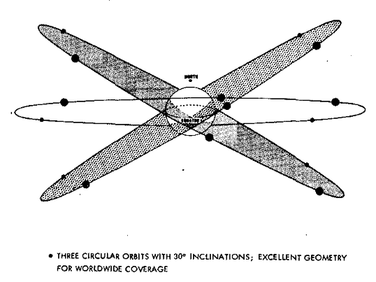
In 1. it is said that "Worldwide coverage (including altitude measurement) can be obtained with 12 to 18 satellites". This is probably the geometric minimum.
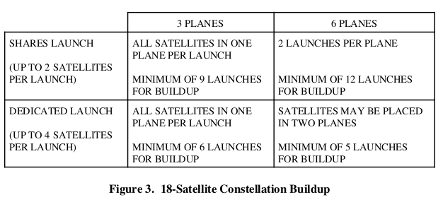
In 2. there is a comparison of the buildup phase in different constellations. With dedicated launches, 6 planes with 3 satellites each requires the least amount of launches:
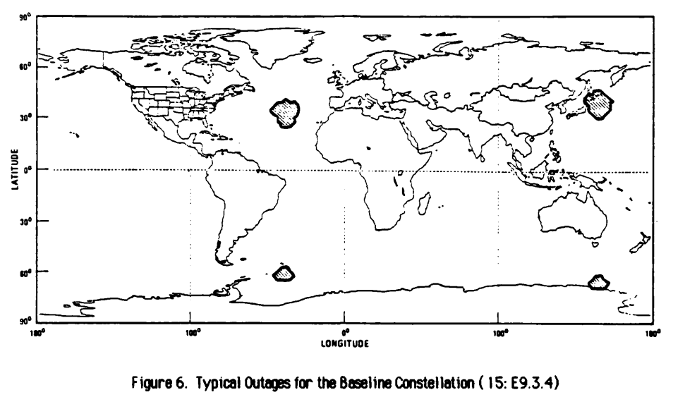
In 3. an elliptic orbit modification of the constellation was considered. This thesis gives a good overview on how the performance of possible constellations were analyzed and compared.
-
1$\begingroup$ "12 to 18 satellites. This is probably the geometric minimum." Not so. In 1983 there were inly 9 GPS satellites, but the survey ship I worked on was able to get 1 meter fixes (using military software) There was sometimes long gaps between satellite passes, so the NAV computer needed to do "running fixes". It also needed to account for ship's heading to allow for location of the GPS antenna on the bridge. $\endgroup$– WoodyCommented Dec 3 at 22:57
-
1$\begingroup$ @Woody The difference is you need 4 satellites in view if you want altitude, but only 3 if you want lat/long. The current orbital geometry actually results in a little worse performance in altitude; it was deemed acceptable because surface users often don't care, and you can get altitude barometrically. $\endgroup$ Commented Dec 3 at 23:03
-
5$\begingroup$ @user71659 In 1983, we were getting altitude, as well as lat/long, with only one satellite above the horizon. The trick was the "running fix". Data would be gathered from successive passes and time-adjusted. This would let the computer calculate where we were at an earlier time in the running fix. This was a survey ship, so we had access to current bleeding edge military software. $\endgroup$– WoodyCommented Dec 3 at 23:25
-
2$\begingroup$ @JohnDoty ... a running fix is also how sextant navigation acquires a fix from a single celestial object (the sun) as it moves with the celestial sphere. $\endgroup$– WoodyCommented Dec 4 at 17:29
-
2$\begingroup$ @U.Windl, the satellites orbit high enough and with sufficient inclination that "world-wide" does include the North Pole. It's a rather important location when you're firing GPS-guided missiles at Moscow from silos in the American Great Plains. $\endgroup$– MarkCommented Dec 4 at 22:53
There's probably no simple answer. In mission design, you sketch out an architecture, do some calculations and simulations, and adjust it a bit. If it's not too far from optimum by some plausible metrics, you propose it.
Realistically, metrics are never terribly accurate representations of how things will play out. “It's tough to make predictions, especially about the future.” -- Yogi Berra. But you do what you can.
Then, as you proceed with the detailed design, the architecture gets "locked in" and becomes hard to change. Too many people are involved, and they each have an investment in the architecture as is.
-
$\begingroup$ Thank you. It's quite practical, I didn't consider this aspect. Maybe I'm too obsessed with calculation. $\endgroup$– H105Commented Dec 3 at 14:32
-
$\begingroup$ Also worth mentioning that there is a minimum number to be useful, so not worth doing if the mission didn’t commit to doing at least that many with an acceptable level of redundancy. $\endgroup$– jmorenoCommented Dec 4 at 3:05
-
3$\begingroup$ This answer could be improved by mentioning some of the relevant metrics or what aspects of the design didn't match the implementation. As it stands now the answer is basically, "they tried some stuff on paper, knew it would be wrong anyway, and went with whatever seemed best", which has nothing at all to do with GPS and describes basically every engineering problem ever. $\endgroup$ Commented Dec 4 at 14:10
-
$\begingroup$ @NuclearHoagie That's the point. It was an engineering problem with murky answers, not a math abstraction with a precise answer. The OP seems to assume it was the latter. $\endgroup$ Commented Dec 4 at 23:11


