4
$\begingroup$

The news item in Science Brazil’s first homemade satellite will put an extra eye on dwindling Amazon forests says:

Right now, Brazil’s Amazon monitoring program relies on flyovers from the U.S. satellite Landsat, which provides high-definition image data every 16 days. More timely alerts about deforestation come from two satellites codeveloped by Brazil and China, CBERS-4 and CBERS-4A, which together provide images every 3 to 4 days.

Amazonia-1’s cameras, which cover an area of 850 kilometers at 65-meter resolution, will be no sharper than those on the existing satellites. But the new addition to the satellite fleet would shorten the gap between flyovers to generate new images every day or two. That frequency increases the chances of getting clear pictures without cloud cover—a common problem in the rainforest—and gives authorities faster alerts about deforestation.

“A day can make all the difference,” says Cláudio Almeida, who coordinates INPE’s Amazonian monitoring program and oversees its official deforestation reports. With near–real-time monitoring, “enforcement teams can go to the right place at the right time,” he says.

The table below gives some orbital information from Wikipedia. All three are in sun-synchronous obits which means that for a given orbit (for circular orbits a given altitude) the inclination is chosen to precess around the Earth once per year to synchronize observations in some way with the day/night cycle.

Question(s):

  1. Why can Amazônia-1 observe the Amazon every day or two while Landsat takes 16 days between observations? Is "orbital magic" at play here?
  2. Why does the quote in Science say every day or two but Wikipedia say "every 4 days"?

Table:

satellite  altitude  inclination   period   interval    Source
             (km)      (deg)     (minutes)  (days)
Landsat-7    705       98.21°      98.83     16       https://en.wikipedia.org/wiki/Landsat_7
Landsat-8    705       98.22°      98.8      --       https://en.wikipedia.org/wiki/Landsat_8
Amazônia-1   756.5     98.51       99.8   "Period of Earth imaging: 4 days" 
https://en.wikipedia.org/wiki/Amaz%C3%B4nia-1

Further reading:
$\endgroup$

3 Answers 3

7
$\begingroup$

Field of view.

Landsat satellites by design have a rather narrow field of view (185 km across) so as to reduce issues with off-nadir resolution while Amazonia-1 by design has a much wider field of view (850 km) so as to reduce the time delay between repeated observations of the same locale. The key sensor on Amazonia-1 is the Advanced Wide Field Imaging Camera (AWFI), with a 850 km field of view. That factor of 4.6 wider field of view means that Amazonia-1 needs fewer orbits between repeat observations.

$\endgroup$
0
5
$\begingroup$

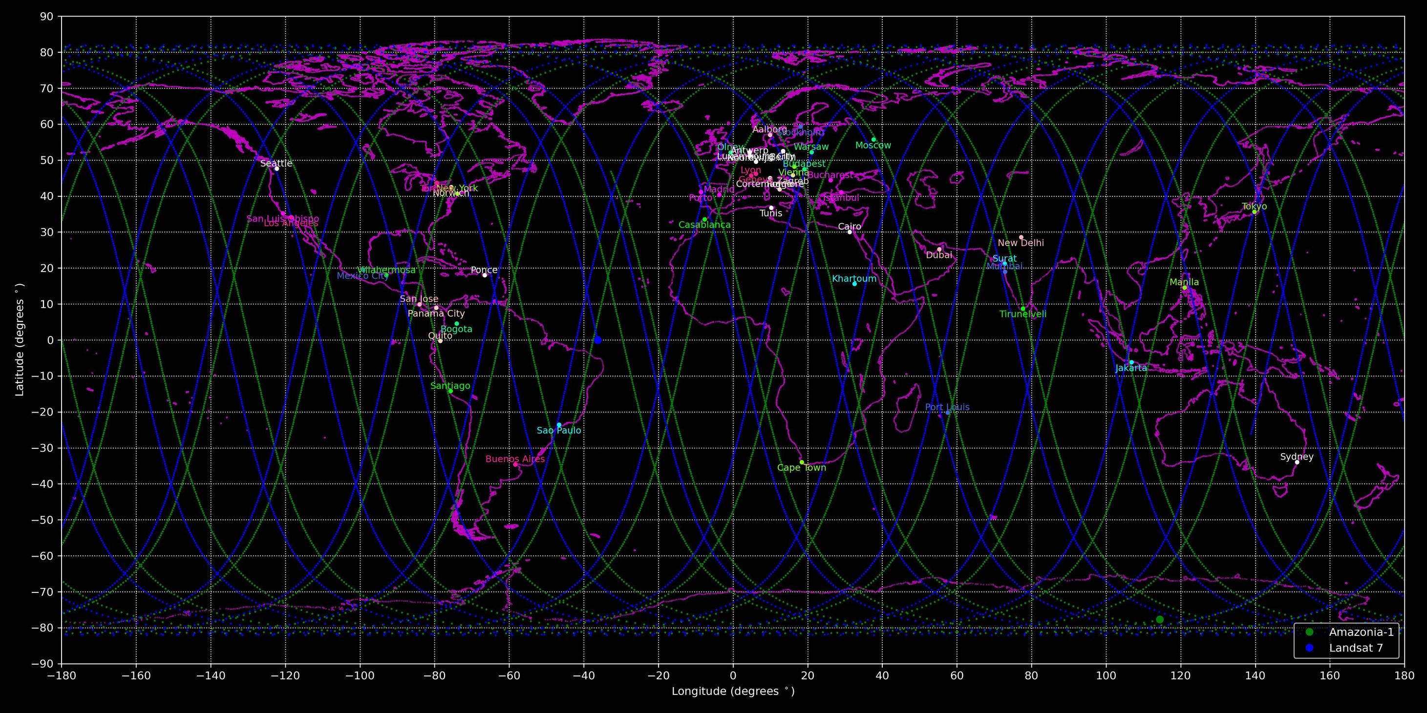
Sun-synchronous orbits are useful for global coverage since they are near polar orbits. Attached is the plot of the groundtracks of Amazonia-1 and Landsat-7 for a 24 hour period. So in one day, each of the satellites makes 2 passes over the Amazon. However the Amazon is massive, and the flyovers are on the order of tens of minutes, so full coverage of the Amazon seems like it would take multiple days, but you could get some strips of images everyday.

However there is also the considerations of sending down the images. Depending on how much data they need to send down, maybe it takes more than 1 pass over a comms station to do so.

So overall, I believe this is less orbits magic (since they are both in similar sun-synchronous orbits), but Amazonia adds 2 more passes per day of the Amazon, which is why they will be able to get data faster. Also, from an operations perspective, Amazonia's main mission is to image the Amazon (from what I've read), while Landsat is imaging the entire Earth. Landsat has a lot more images to send down, so again there could be some communications constraints causing more time in between getting the data.

Also as a side note, sun-synchronous orbits have their inclinations and altitudes set such that the J2 perturbation of the earth causes a drift in the right ascension of the orbit thats equal to the rate of the Earth's change in true anomaly with respect to the sun, which keeps the angle between the orbital plane and the sun vector constant.

24 Hour Groundtracks

$\endgroup$
4
  • 3
    $\begingroup$ Thank you for your answer! Please feel free to mention the tool(s) you use to make plots and to include links to any related resources that other users may find helpful! Just include a mention of any affiliation you have to them (e.g. "see my profile"). Declan Murphy participates here and answers questions about flightclub.io and astrojuanlu does the same for poliastro for example. $\endgroup$
    – uhoh
    Commented Mar 2, 2021 at 23:51
  • 4
    $\begingroup$ I use all my own personal Python tools to make these types of plots, which include using NASA's SPICE software (specifically SpiceyPy, a Python wrapper to the CSPICE library) for ephemeris interpolation, reference frames, etc. I make videos on YouTube (~60 videos as of now) of how to write all the Python for this types of analysis, and others like porkchop plots (and Lambert's), numerical methods, and spacecraft attitude control (I'm only a few videos in this series). I have all the links to these in my profile! As well as links to the Space Engineering Podcast I recently started @uhoh $\endgroup$ Commented Mar 3, 2021 at 0:30
  • 1
    $\begingroup$ I just saw this; would you consider adding a new and nicer looking answer to How can I plot a satellite's orbit in 3D from a TLE using Python and Skyfield? I'm not sure if your nice looking plotting and continent-outlined Earth is public or not, but if so that would be great! I've used this in the past but it's cumbersome. $\endgroup$
    – uhoh
    Commented Mar 3, 2021 at 1:36
  • 2
    $\begingroup$ @uhoh Sounds good, I'll go ahead and put in a new answer in that post. Also, I have a playlist of all the videos that go through the calculations and software of how to make the 2D groundtracks plots using SPICE for the frame rotations. youtube.com/playlist?list=PLOIRBaljOV8ghaN9XcC4ubv-QLPOQByYQ $\endgroup$ Commented Mar 3, 2021 at 2:04
5
$\begingroup$

Landsat orbits repeat their ground tracks almost exactly every sixteen days. Each Landsat sees some part of the Amazon three to six times per day, as the ground tracks @Alfonso Gonzalez posted show, but the interval between one Landsat swath of some part of the Amazon and the next image of the same part of the Amazon by the same Landsat imager, for greatest ease of comparison, happens every sixteen days.

$\endgroup$

Your Answer

By clicking “Post Your Answer”, you agree to our terms of service and acknowledge you have read our privacy policy.

Not the answer you're looking for? Browse other questions tagged or ask your own question.