5
$\begingroup$

I would like to retrieve data about position of Spirit along its travel on Mars surface using webgeocalc; I found a document which lists all "needed" kernels... but they are not enough, SPICE is not able to transform from IAU_MARS frame to MER-2_ROVER frame:

CSPICE_N0067: CSPICE.pxform: SPICE(NOFRAMECONNECT): [pxform_c --> PXFORM --> REFCHG] At epoch 1.2618726418391E+08 TDB (2004 JAN 01 00:01:04.183 TDB), there is insufficient information available to transform from reference frame 10014 (IAU_MARS) to reference frame -254000 (MER-2_ROVER). Frame IAU_MARS could be transformed to frame 1 (J2000). MER-2_ROVER is a CK frame; a CK file containing data for instrument or structure -254000 at the epoch shown above, as well as a corresponding SCLK kernel, must be loaded in order to use this frame. Failure to find required CK data could be due to one or more CK files not having been loaded, or to the epoch shown above lying within a coverage gap or beyond the coverage bounds of the loaded CK files. It is also possible that no loaded CK file has required angular velocity data for the input epoch, even if a loaded CK does have attitude data for that epoch. You can use CKBRIEF with the -dump option to display coverage intervals of a CK file.

This is the relationship between frames:

   "J2000"
-------------------
        |
        |<-pck
        |
        v
   "IAU_MARS" 
   ---------- 
        |
        |<-fixed
        |
        v
   "MER-2_TOPO"
   ------------
        |
        |<-fixed
        |
        v
"MER-2_LOCAL_LEVEL"
-------------------
        |
        |<-ck
        |
        |
        v
-------------------
  "MER-2_ROVER"


       Name                      Relative to         Type    NAIF ID

  MER-2_TOPO                 IAU_MARS                FIXED   -254900
  MER-2_LOCAL_LEVEL          MER-2_TOPO              FIXED   -254910
  MER-2_SURFACE_FIXED        MER-2_LOCAL_LEVEL       FIXED   -254920
  MER-2_ROVER                MER-2_LOCAL_LEVEL       CK      -254000
  MER-2_LANDER               MER-2_LOCAL_LEVEL       FIXED   -254700
  MER-2_CRUISE               J2000                   CK      -254800

I manually added dozens of other kernels, but no luck yet, there is always something missing.

$\endgroup$
4
  • $\begingroup$ I think you may be missing a SCLK (Spacecraft clock) kernel based on the message, maybe some others. I found this which is part of a PDS delivery and so should be complete to allow reproducing results. Search for "The FURNSH list below includes all SPICE kernels needed to compute cruise position and orientation, and rover surface position and orientation along with orientation of the rover structures (PMA, IDD, and HGA) and the camera parameters." and then look at the KERNELS_TO_LOAD just below - hope this helps $\endgroup$ Commented Jul 12, 2022 at 18:54
  • $\begingroup$ you found... the link I posted in my question. :-) Instead, I found the answer: data are not there. I contacted the NASA officer which manages webgeocalc: he said that only position data are fully available; orientation data are so sparse and incomplete that the only way to get useful results from webgeocalc is setting it to ignore errors... and to live with the holes in the data. $\endgroup$
    – jumpjack
    Commented Jul 13, 2022 at 6:25
  • $\begingroup$ Oops sorry about that... I guess great minds think alike though... I'm a little surprised the telemetry data on orientation which presumably was coming back wasn't turned into a SPICE kernel. The Analyst's Notebook talks about the Rover Motion Counter data which might have the orientation data but looks like a lot of work to make use of as it apparently resets the encoder positions periodically. What a pain... $\endgroup$ Commented Jul 13, 2022 at 15:35
  • $\begingroup$ no, the rover motion counter is just... a counter: every time pancam or arm was moved, its counter was incremented by 1, without any detail in the counter itself. Counter is in format (SITE,DRIVE,IDD,PMA,HGA):137 sites were created for MER2/Spirit; every time the rover moved, DRIVE (aka POSITION) counter was incremented, until team decided to pass to a new site and reset DRIVE to 0; similarly,every time IDD (robotic arm),PMA (Pancam Mast Assembly) or HGA (High Gain Antenna) was moved, its counter was increased. Orientation data are "buried" into PDS label of each image, and they are thousands! $\endgroup$
    – jumpjack
    Commented Jul 14, 2022 at 8:31

1 Answer 1

1
$\begingroup$

Position

I found the answer for position.

The only kernels needed for the https://wgc.jpl.nasa.gov:8443/webgeocalc/#StateVector are the ones included in "main MER release" in the list:

kernel selection

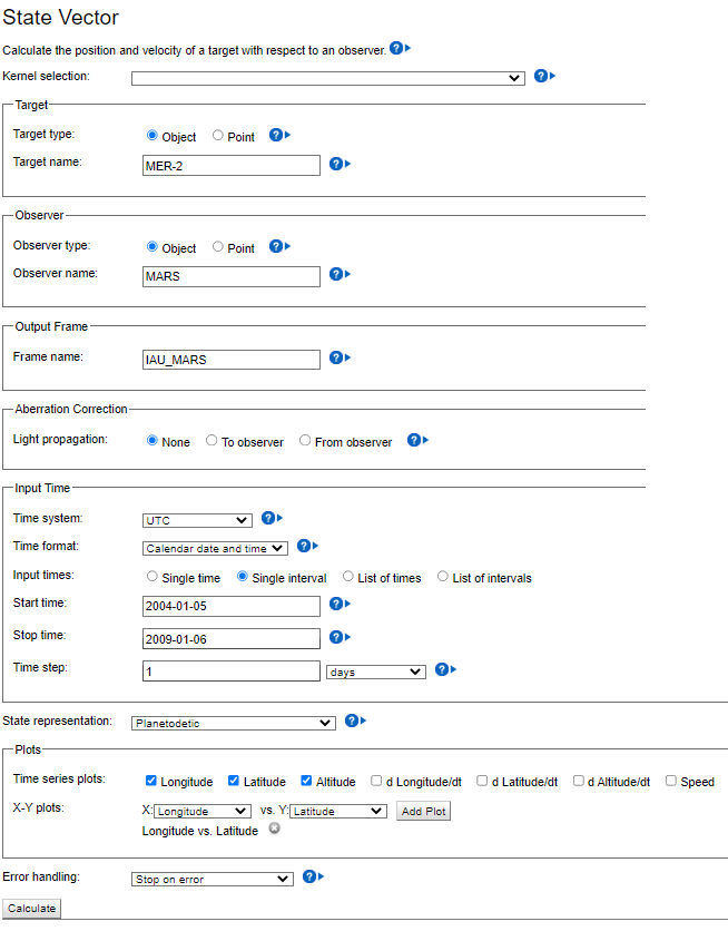
Then select "MER-2" as target and "MARS" as reference frame:

settings

You will get the elevation profile:

elevation profile

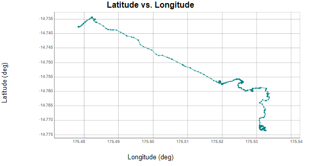
...and, manually zooming a lot, the traverse map:

traverse map

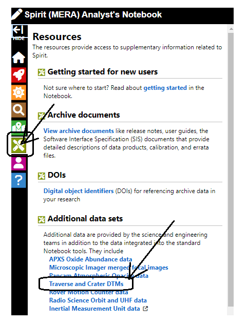
Traverse map data are also available from https://an.rsl.wustl.edu/mera/merxbrowser/an3.aspx?, clicking on "resources":

traverse map notebook

Orientation

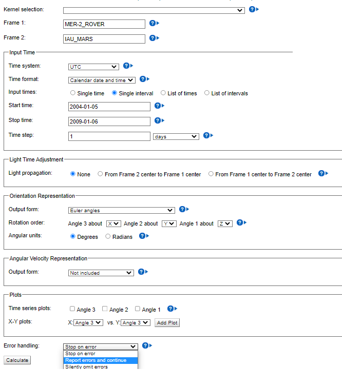
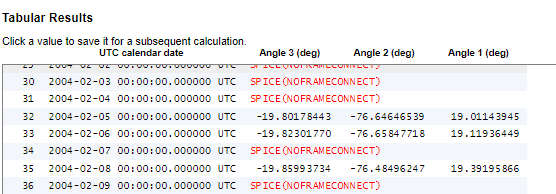
Different story for orientation: some data are missing, that's why webgeocalc fails, so it must be set to ignore errors in the "frame transformation" page:

https://wgc.jpl.nasa.gov:8443/webgeocalc/#FrameTransformation

orientation settings

Results:

orientation results

$\endgroup$

Your Answer

By clicking “Post Your Answer”, you agree to our terms of service and acknowledge you have read our privacy policy.

Not the answer you're looking for? Browse other questions tagged or ask your own question.