9
$\begingroup$

I've recently seen movie Gravity. The protagonist detaches from the shuttle and is hurled into space. The mission commander then asks her for GPS coordinates.

This happenned while they were fixing Hubble Space Telescope. But later they board ISS. I'm not really sure about height of those two objects.

So is it possible to use GPS there? Disregarding the fact, that coordinates would be probably quite off...

$\endgroup$
7
  • 1
    $\begingroup$ Sounds like a duplicate, plus the coordinates won't be off due to triangulation (you determine a point in 3D space, not just a point on the surface). $\endgroup$
    – Mario
    Commented Oct 6, 2013 at 11:01
  • 2
    $\begingroup$ Not a duplicate! This question is about position determination, the linked "dupe" is about attitude determination, which is entirely different. GPS is usually used for the former and not the latter. $\endgroup$ Commented Jul 5, 2019 at 20:11
  • $\begingroup$ @Mario Afaik the GPS gives altitude information, too. Only most devices don't say it. $\endgroup$
    – peterh
    Commented Jul 5, 2019 at 22:32
  • 1
    $\begingroup$ Possible duplicate of Will Glonass, Galileo, or BeiDou-2 satellites provide better cis-lunar navigation than GPS? $\endgroup$
    – Manu H
    Commented Jul 6, 2019 at 7:28
  • $\begingroup$ @ManuH This question is about the ISS, that question is about cis-lunar space. There's no spatial overlap! Do you really think that the answer there is a better answers to this question than the answers here? I don't, and I'm the author of that question. Have a closer look at that answer, then check the three answers here. Thanks! $\endgroup$
    – uhoh
    Commented Jul 10, 2019 at 15:15

4 Answers 4

12
$\begingroup$

Does GPS work at ISS?

  1. There's certainly no reason for it not to!
  2. It's likely to be "yes" for at least some of the other GNSS systems as well. See Will Glonass, Galileo, or BeiDou-2 satellites provide better cis-lunar navigation than GPS?
  3. Also see answers to How far up have satellites used a GNSS for positioning, and how does the precision degrade with altitude?

As seen from a GPS satellite, the Earth falls into a cone with a half-angle of 13.5 degrees wide, and the cone that includes the ISS' orbit has only a slightly larger half-angle of 14.3 degrees; at it's maximum deviation the ISS is only 0.8 degrees beyond the edge of the Earth.

There's more information on this in the quest Will Glonass, Galileo, or BeiDou-2 satellites provide better cis-lunar navigation than GPS? and in its answer, I've included one slide from the linked presentation Enabling a Fully Interoperable GNSS Space Service Volume below, as an image from this answer

The ISS, many satellites, and rockets launching from Earth all use GPS receivers that are optimized to work in spaceflight, which means they can still work with order 10 km/sec velocities relative to the Earth. Most GPS receivers we use have special firmware that actively blocks them from working above a certain altitude or speed; you can read more about that in this answer.

So is it possible to use GPS there? Disregarding the fact, that coordinates would be probably quite off...

Yes, and the coordinates will have the same if not better accuracy than devices on Earth because there is no distortion due to variable water vapor in the Earths' atmosphere.

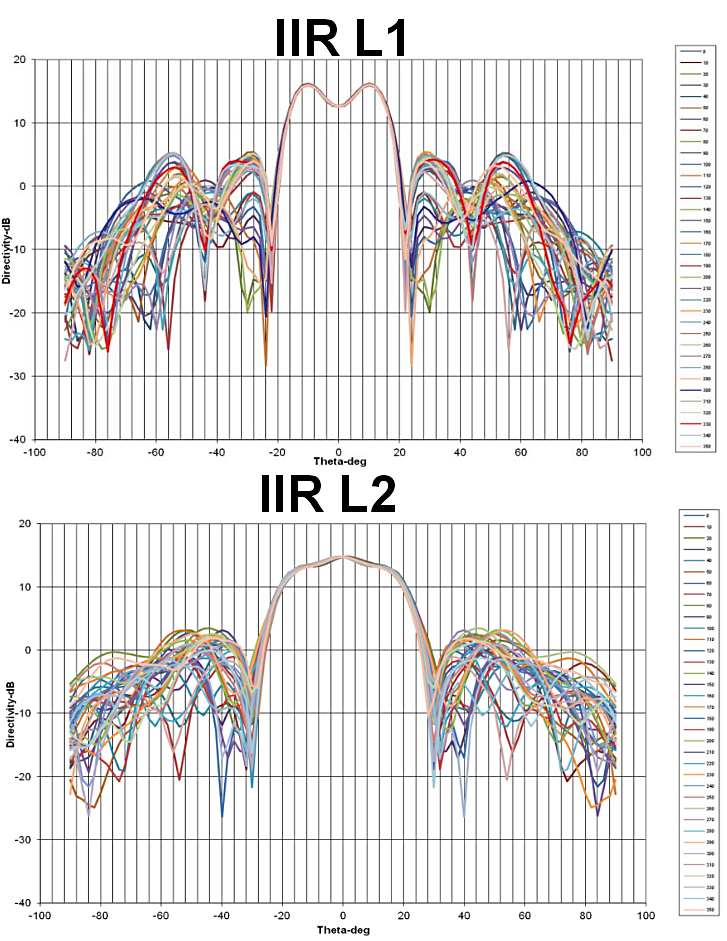
enter image description here

enter image description here

$\endgroup$
4
  • 7
    $\begingroup$ This is correct but is missing a vital fact - the ISS uses GPS, so the answer is trivially yes. (You mention it has receivers, but it's buried in the wall of text) $\endgroup$ Commented Jul 6, 2019 at 11:45
  • $\begingroup$ @OrganicMarble I've intentionally left that answer to those more knowledgable of those systems. $\endgroup$
    – uhoh
    Commented Jul 6, 2019 at 12:20
  • $\begingroup$ And it also uses differential GPS for attitude on the ends of the ISS ! $\endgroup$
    – zephyr0110
    Commented Jul 7, 2019 at 8:00
  • 1
    $\begingroup$ @Prakhar would you consider adding an answer with a link to a source? I think that would be a really helpful contribution here, thank you! (you might find something on this site already, a quick search may be quite productive) $\endgroup$
    – uhoh
    Commented Jul 7, 2019 at 8:15
7
$\begingroup$

As an addendum to the other answers, although GPS will work on the ISS, conventional, consumer receivers will not. GPS modules sold to civilians in phones, cars, or other devices have restrictions embedded within them, nominally to prevent people from making their own missiles or ICBM's.

The two typical restrictions are

  1. No exceeding 18000 meters in altitude
  2. No exceeding 1000 knots in speed

Different manufacturers apply these rules differently, some with an OR and others with AND.

$\endgroup$
7
$\begingroup$

Yes. In fact the ISS uses GPS as the primary source of information in its attitude control system.

The US segment of ISS has been using GPS as its primary source of information for position, velocity, attitude, and time since April 2002

Source

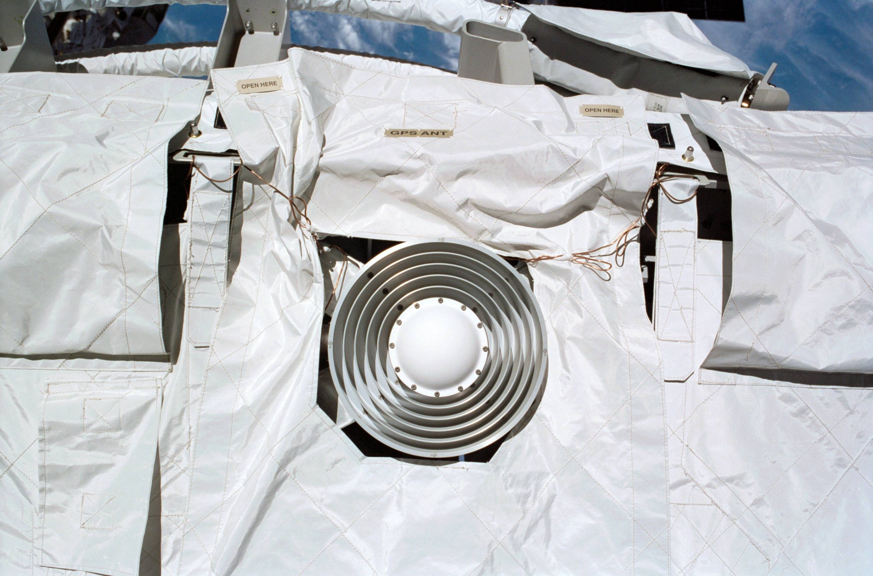
Here is a picture of one of the ISS GPS antennas.

enter image description here (Source: NASA)

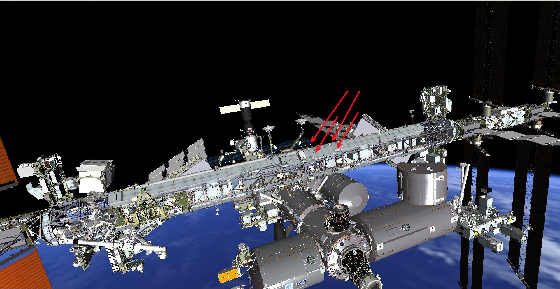
The four antennas are located on the "upper" surface of the S0 truss, as shown in this DOUG rendering.

enter image description here

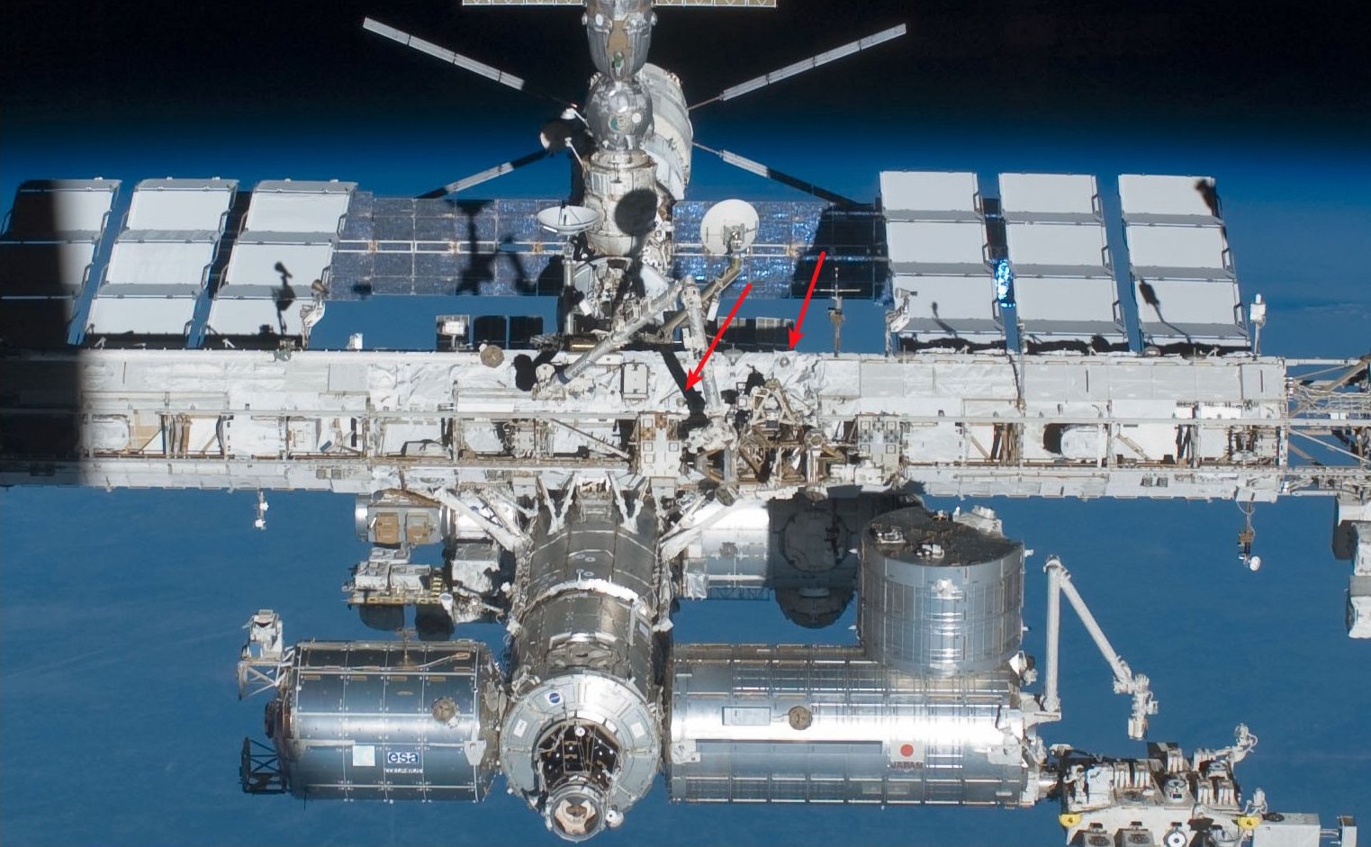
Two can be seen in this NASA photo.

enter image description here

$\endgroup$
5
  • 1
    $\begingroup$ I was about to balk at that weird-looking thing being a GPS antenna until I noticed that answers to What is the large circular device with a dozen concentric circles on Sentinel 3B? suggest that's an isoflux antenna with a very wide-angle and specifically shaped reception pattern. Very nice find! I don't know my way around the ISS very well, are you able to figure out which way it points? $\endgroup$
    – uhoh
    Commented Jul 11, 2019 at 4:09
  • 1
    $\begingroup$ I'll add a locator picture tomorrow, hitting the sack here. Btw, it's labeled in the picture. $\endgroup$ Commented Jul 11, 2019 at 4:30
  • $\begingroup$ oh, duh! I was looking at Fig. 10 but it's right there in Fig. 1B, and of course your image shows that it's certainly not pointed toward Earth. Yes, it probably points "up" just like antennas on Earth. $\endgroup$
    – uhoh
    Commented Jul 11, 2019 at 4:57
  • $\begingroup$ Having looked into this, I wonder if you have anything to post at Current status of the use of GPS mutli-antenna time differentials for satellite attitude determination? $\endgroup$
    – uhoh
    Commented Jul 12, 2019 at 2:49
  • 1
    $\begingroup$ Sorry, I consider GPS to be a magic genie that tells me where I am. Shuttle and ISS used it, but I don't know details. $\endgroup$ Commented Jul 12, 2019 at 3:43
4
$\begingroup$

The answer here describes the attitude determination goals of the future russian crew module federatsiya. The idea is to use two different GPS receivers at the end of the spacecraft, when the spacecraft is rotating(almost tumbling) and looses its absolute attitude reference, this method will be able to give attitude within certain time using signal delays of the GPS. Ideally, one would require 3 GPS antennas for solution for 3 axis. But this assumes the spacecraft is tumbling, therefore if given sufficient time one can probably converge to proper attitude using some algorithm. Also, as mentioned in the paper provided in the above link, the soyuz MS does use gyro in loop for the attitude determination using GPS. However, the federatsiya's one of the failure modes assumes gyro has failed and can get attitude without gyro too. Obviously this must have time penalty

ISS uses same technique, I think as Technology Demonstrator as mentioned in this link

$\endgroup$

Your Answer

By clicking “Post Your Answer”, you agree to our terms of service and acknowledge you have read our privacy policy.

Not the answer you're looking for? Browse other questions tagged or ask your own question.