SHORT ANSWER:
4-station seismology network nodes should be far (1000s km) from each other.
LONG ANSWER:
From Planetary Decadal Survey study of Mars Geophysical Network:
In order to fully reach the science goals described above, seismic investigations would require a network
of at least four stations: three with a spacing of approximately 3,000 km (i.e., 50°) and an antipodal station
capable of detecting seismic waves traveling though the core from an event simultaneously detected by
the others. Such a network might locate, through travel-time analysis, more than 80 quakes per (Earth)
year and would be robust to unexpected high mantle attenuation or low seismic activity. With four or more
landers, fine details of the internal structure, such as the dichotomy or other large unit differences, mantle
discontinuities, and anisotropy, might also be characterized.
A two-station network is considered the minimum network size to
address the baseline science of MGN. Determination of the internal
structure is also possible with fewer stations under certain
assumptions, if they are provided with the highest quality
instruments. With data from two seismic stations, true seismic events
should be readily distinguishable from local noise, and approximate
locations of events could be determined using reasonable assumptions.
If both are located near a seismically active region (e.g., Tharsis),
they should be able to detect sufficient shallow quakes, in addition
to meteorite impacts, to model the upper mantle beneath the two
landers. Two stations allow the velocity dispersion analysis of
surface waves from larger quakes. Atmospherically generated seismic
“noise” could also provide mean phase velocities of surface waves (and
thus crustal and upper mantle structure) using the crosscorrelation
techniques [24]. In addition, the data from each station could be
analyzed using advanced single-station seismic techniques, such as
receiver function analysis, solid tide measurements, and possibly
normal modes.
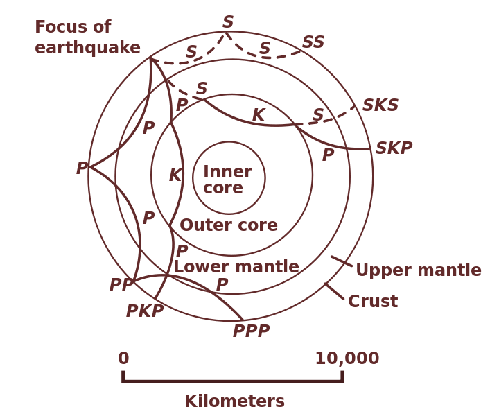
The problem with one-point seismic station - it have uncertainties about locations of seismic events. Every event creates multitude of seismic waves (see Wikipedia-Seismology for more info). Different types of seismic waves have different velocities. Also same-type waves can reach detector in different ways and different times. Here is the example of seismic waves' paths inside Earth:
 source
With single station you need some model-based assumptions about velocities of different types of waves in different layers of Mars. The assumptions can be not-so-good. Several-points network allows to cross-check these models and deduce wich is best.
The uncertainties can be resolved by satellite imagery data, for example MRO imagery can find locations of new meteorite impacts and landslides that could cause seismic events. But really only small amount of them can be found, and without exact time of the event.
I suppose single-seismometer data can be used for seismic model refinement if it have enough statistics (many seismic events).
From this develompent report of SEIS instrument
Traditional seismic analysis has been based largely
on arrival times of body waves acquired by a widely
distributed network of stations. However, over the
past few decades a wide variety of analysis
techniques have been developed for extracting
information about the properties of the Earth’s
interior and about seismic events themselves using
the data acquired from a single seismometer. The
collection of a high-quality broad-band seismic data
set for Mars will provide an invaluable resource for
the seismological community to apply various current
and future techniques to learn more about Mars.
Among the science goals which can be achieved by a
single VBB seismometer will be determination of
core size through measurement of the amplitude of
the solid tide induced by Phobos, determination of
the seismicity by the monitoring body waves, a priori
location of epicenters with P-S and azimuth
determination, identification of internal discontinuities
by analysis of seismic secondary phases,
determination of the crustal thickness below the
landing site by the receiver function analysis method,
and, if large quakes are detected or if a low seismic
noise threshold is achieved, determination of the
upper mantle structure by normal modes, surface
waves and noise analysis.
