Since Buran has managed to return without crew on board, I assume computers had to know its position relatively accurately as it approached the runway for landing. How was this achieved?
1 Answer
I haven't found much about the Buran GNC systems in general.
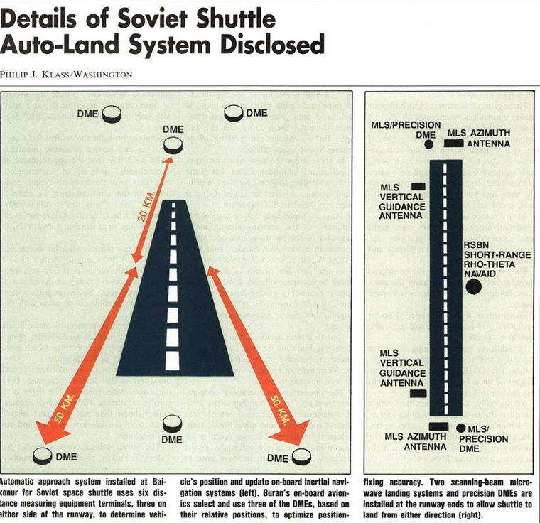
You asked about the landing, though, and there was an article in the December 12 1988 issue of Aviation Week (sorry, paywalled) that described its autoland system extensively. Unsurprisingly, it was much like the US Shuttle's system, relying on ground based distance-measuring equipment to update its inertial guidance system. This is similar to how the US shuttle used TACAN (TACtical Air Navigation) stations for landing. On final approach, Microwave Scanning Beam Landing Systems (MSBLS or just MLS) were used, again similarly to the US Shuttle.
-
$\begingroup$ This is more or less how autoland works on aircraft, which was already used in scheduled passenger service for almost a decade when the Shuttle was designed and over a decade when Buran was designed, so it was already well proven, and is probably no coincidence. (Autoland development started in the late 40s in fog-plagued Britain.) $\endgroup$ Commented Feb 9, 2019 at 5:19
-
$\begingroup$ Agreed, I did not mean that Buran copied shuttle in this regard, it was the technology of the time, pre-GPS. $\endgroup$ Commented Feb 9, 2019 at 5:20
-
1$\begingroup$ There are a few pages on the GNC system in the book Energia-Buran by Hendrickx and Vis, including the 2 graphics you've found. $\endgroup$– HobbesCommented Feb 9, 2019 at 10:53
