5
$\begingroup$

Inertial Navigation Systems calculate position by measuring acceleration. But they are unable to measure gravitational acceleration since gravity always acts equally on the test mass and the instrument platform.

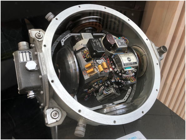
Inertial Navigation Systems use Inertial Measurement Units (IMUs) to sense acceleration. Essential components of IMUs include triads of

• Accelerometers to measure linear acceleration

• Gyroscopes to measure angular acceleration

An IMU consists of two triads: 3 accelerometers and 3 gyroscopes. This provides 6-axis measurements of linear and angular acceleration, from which the state vector can be calculated by a Computational Unit (CU).

The combination of IMU and CU is used to determine the attitude, position, and velocity of the system based on the raw measurements from the IMU and a known initial starting position.

Apollo Inertial Measurement Unit

Apollo Inertial Measurement Unit

The accelerometers measure the combined linear acceleration plus the pseudo-acceleration caused by gravity. To obtain the system's linear acceleration due to motion, the gravitational pseudo-acceleration must be subtracted from the accelerometer measurement using assumptions of the local gravitational acceleration.

For instance, if the system was sitting on the kitchen table, the vertical axis accelerometer would report a 1g vertical acceleration despite the fact it is stationary, while if it were in free-fall it would report zero acceleration despite the fact it is accelerating.

The CU could easily compensate for gravity if the system were in a known uniform gravitational field. But spacecraft operate in variable gravitational fields. Think of a satellite in Low Lunar Orbit or NRHO

An IMU in free-fall will always "think" it is travelling in a straight line at a constant velocity despite the fact it is travelling in a curved path.

How do Inertial navigation Systems compensate for their inability to measure gravitational acceleration? Do they carry a “Gravitational Ephemeris”?
$\endgroup$
2
  • 1
    $\begingroup$ The IMU is just a sensor, it is used in combination with other instruments to produce a position. E.g. for Apollo, it was periodically corrected with a sextant: ion.org/museum/item_view.cfm?cid=6&scid=5&iid=293 . By contrast, Artemis uses a camera and a system programmed to detect individual features on the lunar surface. $\endgroup$ Commented Dec 2, 2023 at 3:43
  • 1
    $\begingroup$ "gravitational ephemeris" is an interesting way to put it, but I think that was indeed the case for Apollo. I seem to recall a story--maybe it's in Eyles' "Sunburst and Luminary"--that Draper was convinced they could fly the Apollo missions on the INS alone without ground or sextant sighting updates. I think they managed to demo it once? I'll try to track the story down. but that would require position and velocity integration inside a model Earth-Moon(-Sun?) system to work right, as you say. $\endgroup$
    – Erin Anne
    Commented Dec 2, 2023 at 8:36

1 Answer 1

5
$\begingroup$

Partial answer:

For the Space Shuttle (a small US fleet of crewed LEO spaceplanes which flew intermittently from 1981-2011), the local acceleration due to gravity was calculated onboard based on the vehicle position. So, as you say, they kinda did "carry a 'Gravitational Ephemeris'”

Because the vehicle's location changes with respect to the Earth as it orbits, the state vector is constantly changing, and nav is continually having to recompute it. This is done in the General Purpose Computers (GPCs) via an algorithm known as “super-g navigation.” The Super-g Algorithm performs the following functions:

a. Given the state vector and gravitational acceleration from the last cycle, a new position vector is estimated using either modeled drag acceleration or IMU-sensed acceleration.

b. The gravity at the new position is calculated.

c. Using the change in gravity from the past to the current cycle, the position and velocity vectors are recomputed.

From Guidance and Control / Insertion, Orbit, Deorbit Training Manual paragraph 2.3

More information about the gravity model is available in the FDO On-orbit Console Handbook paragraph 3.5.1.1

The Orbiter's gravity potential model utilizes an infinite series expansion of Legendre polynomials called Pines method. This recursive algorithm accesses a database of harmonic coefficients arranged in lower-triangular-matrix form. An element of the database is termed Jn,m, where the row n is the harmonic's degree and the column m is its order. When m=0, the coefficient's effect is symmetric about a parallel of latitude, and it's termed a zonal harmonic. When n = m for a matrix diagonal coefficient, its influence is symmetric about a great circle of longitude, and it’s termed a sectorial harmonic. No latitude or longitude symmetry is associated with the action of coefficients having n ≠ m, and they are termed tesseral harmonics. The onboard model is configured with a Goddard Earth Model 9 (GEM9) database truncated to fourth degree and order.

$\endgroup$
2
  • 1
    $\begingroup$ From the linked document, I understand the Inertial Navigation Units on Shuttles uses a gravity model which consults a database matrix for fudge factors associated with the DR lat/long/altitude. How is this done with deep space missions? Is there an altitude where perturbations decrease to the point where Earth (and Moon) can be treated as ideal spheres? I assume the Moon’s “lumpiness” causes difficulties with low orbits. $\endgroup$
    – Woody
    Commented Dec 3, 2023 at 3:14
  • 1
    $\begingroup$ @Woody the above consists of my total knowledge of this subject. $\endgroup$ Commented Dec 3, 2023 at 3:30

Your Answer

By clicking “Post Your Answer”, you agree to our terms of service and acknowledge you have read our privacy policy.

Not the answer you're looking for? Browse other questions tagged or ask your own question.