4
$\begingroup$

The 34 day launch window for the OSIRIS-REx probe will open in about five weeks (early September 2016), and it's approach to the near earth asteroid 101955 Bennu (provisional designation 1999 RQ36) is planned to start about two years later around August 2018. Currently the plan is to stay with the asteroid until the next return to earth opportunity. The plan is to start back in March 2021, and return to earth in September 2023.

In the year 2135 Bennu may pass through a "gravitational keyhole" - a small point in position (and velocity) in this case between the Earth and the Moon. At that point, the future trajectory is very sensitive to the exact orbit through the gravitational fields of the Earth and Moon.

One distinguishing feature of this mission is the planned collection of 60 to 2000 grams of material and return it to earth for study. One reason for this might be that Bennu currently has some possibility of eventually striking earth in another roughly 150 years, and a wide range of information about the object will be valuable.

Photographs and various other measurements will collect information about the surface. According to Wikipedia, detailed study of the surface will be required to understand its interaction with sunlight. Details of the shape, reflectivity and rotational dynamics are necessary to predict the impact of solar photon pressure and the Yarkovsky effect, both of which need to be calculated using a realistic model of the asteroid rather than using that of a sphere with uniform surface properties.

Here is a nice presentation and paper on Bennu's orbit and study.

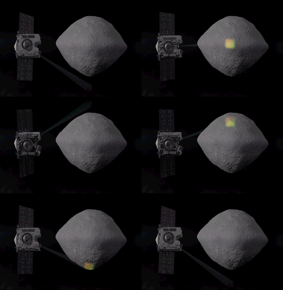
What are the types of measurements will be done? With which technologies will OSIRIS-REx scan the surface of Bennu? What exactly is hoped to be learned about the shape and properties of the surface?

enter image description here

above: subset of frames from the very nice 4MB GIF in this NASA webpage.

side note: While the Pioneer anomaly (discussed also in this question and its answer) was proposed to be related to anisotropy in the radiation of thermal energy due to (mostly) internal heat sources, the excellent analysis here illustrates the important of detailed models of heating, thermal transport, and radiation from a complex body in order to more precisely predict radiative (and also reflective) photon recoil.
$\endgroup$
4
  • 1
    $\begingroup$ I don't really know enough to commit to a full answer, but I do know that OSIRIS-Rex will be looking for organics, because this is actually a sample-return mission. The OSIRIS-Rex Wikipedia page has a detailed list of the instruments. $\endgroup$
    – Phiteros
    Commented Aug 1, 2016 at 14:06
  • $\begingroup$ @Phiteros Thanks! I think the sample-return is an exciting aspect of the mission, and can (and will) generate several question, and for sure the characterization of organic molecules will be very important. But if I calculate correctly the spacecraft may be in close proximity to the asteroid for about two and a half years (this could change) and the GIF shows some kind of "scanning". I'm curious what it will measure about the entire asteroid while it is "there in person" so to speak. Is that some kind of laser or microwave probe, or is that just a camera taking pictures? $\endgroup$
    – uhoh
    Commented Aug 1, 2016 at 14:15
  • 1
    $\begingroup$ I know that it is a combination of mapping (images) and composition measurements (spectroscopy). Using the composition map, they will identify the best places to collect a sample. $\endgroup$
    – Phiteros
    Commented Aug 1, 2016 at 14:17
  • $\begingroup$ The "scanning" is probably the Lidar, which is mentioned in Wikipedia page Phiteros has mentioned. It's a laser scanning device that measures the surface shape precisely. (The main NASA page doesn't have much info on this instrument, maybe because it's Canadian.) $\endgroup$
    – Andy
    Commented Aug 1, 2016 at 14:52

2 Answers 2

6
$\begingroup$

OSIRIS-REx is packed all full of good stuff. I'll throw together a quick list of the scanning ones you're interested in.

Also of note is that the entire spacecraft will be making that scanning motion shown in the gif, so as the asteroid rotates, all of these instruments will be able to have full coverage of it.

OSIRIS-REx Visible and Infrared Spectrometer (OVIRS)

OVIRS is a point spectrometer, and will be used to create an organic and mineral map of the entire asteroid. It has a resolution of 20m from 5km away, which will allow for larger scale mapping, and also can shift down to 0.08-2m resolution to create a detailed up-close map of the eventual chosen sample return site.

OSIRIS-REx Thermal Emission Spectrometer (OTES)

OTES is a thermal spectrometer. It will have a similar function to OVIRS, and will also play a role in measuring the total thermal energy released by Bennu.

Regolith X-ray Imaging Spectrometer (REXIS)

How REXIS works is well above my pay grade, but I think I'll chalk it up to "nuclear magic". Seriously though, on a broad level, solar wind and radiation interacts with the surface on the asteroid, and releases radiation that can be detected by REXIS. This released radiation contains signatures based on the material in the asteroid that released them. The signatures can be measured, and after processing on the ground, you have an elemental abundance map that can help supplement the spectrometers described above.

PolyCam

An 8in telescope that will be the first onboard object to see the asteroid. Once it is closer, it will be used to create high resolution images of the surface.

MapCam

A middle/close range camera with 1m resolution, designed to search for asteroid plumes and satelites in the "Preliminary Survey" phase of the mission. It will also be used for high resolution imagery of the chosen sample site.

SamCam

Close range camera designed to document the sample acquisition event.

OSIRIS-REx Laser Altimeter (OLA)

LIDAR scanning system to create a detailed topographic map of the surface. Funded by the Canadian Space Agency in exchange for a fraction of the returned sample, it is an improved version of a Canadian LIDAR system that has been used on the Phoenix Mars Lander and an Air Force Satellite. It will be used to create an overall topographic map early on in the mission, and then more detailed maps once potential sites are chosen. This system will give us the best topographic map of an asteroid we have ever had.

And just to give a better idea of where all of these instruments fit into the mission as a whole:


There are 4 major phases of surveying Bennu:

  1. Preliminary Survey: Searching for asteroid plumes (like here), any natural satellites, and measuring the Yarkovsky effect, as you mentioned above.
  2. Orbital A: Transition from star based navigation (using the position of the stars as captured by an onboard camera and the orientation of the satellite to determine position) to landmark-based navigation using the preliminary imagery captured by the cameras.
  3. Detailed Survey: Making detailed maps of the surface, using not only topographic data from the OLA, but the spectrometers as well. Scientists will identify potential sample sites during this phase.
  4. Orbital B: A continuation of Detailed Survey with more of a focus on the potential sample sites selected in that phase. This is where we will likely see the much higher resolution modes for the sensors mentioned above. By the end of this phase, a sample site should be chosen.

A treasure trove of information about the instruments of OSIRIS-REx can be found here

Edit: Today NASA released a profile of the OLA

$\endgroup$
2
  • $\begingroup$ Excellent! This is a really helpful overview of the remote scanning of Bennu. The X-ray fluorescence "magic" has two concepts. The X-ray fluorescence is a lot like using a UV light to stimulate visible fluorescence here at home, except it's X-ray photons instead of UV-vis photons, and the transitions are in the deeper electron shells of the heavy atoms. The X-ray intensity and spectrum from the sun can vary quite a bit. The other part is the coded aperture camera to build up an X-ray energy-resolved image. $\endgroup$
    – uhoh
    Commented Aug 9, 2016 at 1:32
  • $\begingroup$ Very nice video! You could consider pasting the video at he bottom of your answer so people see it (or even a screenshot of them holding it or testing it) - some of us remember shooting lasers at asteroids also! $\endgroup$
    – uhoh
    Commented Aug 12, 2016 at 20:09
2
$\begingroup$

For an unrelated purpose, I retrieved the Mission Requirements Document (OSIRIS-REx-RQMT-0001) for OSIRIS-REx. It details the minimum performance requirements for the mission.

We can look at requirements section 3.3: Bennu Global Properties, Chemistry & Minerology Mapping Requirements. Here are the requirments:

  • OSIRIS‐REx shall image > 80% of the surface of Bennu with < 21cm spatial resolution (4‐pixel criterion) to produce a global mosaic, stereo images, mosaics of hazards and regions of interest, and image sequences of the asteroid surface. (Subsystem: Mission System, Pointing, OCAMS, Ground System, SPOC, Spacecraft)

  • OSIRIS‐REx shall, for > 80% of the asteroid surface, produce a topographic map at spatial and vertical resolution < 1m. (Subsystem: Mission System, OLA, SPOC, OCAMS)

  • OSIRIS‐REx shall produce a > 1 million vector shape model. (1 million vectors provides ~1 m2 tiles on shape model) (Subsystem: Pointing, SPOC)

  • OSIRIS‐REx shall determine the shape model center of figure to within 1‐m. (Subsystem: SPOC)

  • OSIRIS‐REx shall designate a prime meridian using a distinctive surface feature and define the coordinate system for Bennu. (Subsystem: SPOC)

  • OSIRIS‐REx shall, for > 80% of the asteroid surface, produce a slope‐distribution map with a precision of +/‐ 7.5° in slope, relative to the geoid surface, and spatial resolution < 1m. (Subsystem: Mission System, OLA, OCAMS, SPOC)

  • OSIRIS‐REx shall determine the rotation pole (right ascension, declination, and obliquity) of Bennu relative to J2000 to within 1° in each parameter. (Subsystem: SPOC)

  • OSIRIS‐REx shall determine the amount of wobble in the rotation pole of Bennu to within 1°. (Subsystem: SPOC)

  • OSIRIS‐REx shall measure the rotation period of Bennu to within 10 seconds. (Subsystem: SPOC)

  • OSIRIS‐REx shall, for > 80% of the asteroid surface, map the surface gravity field to within 5x10‐6 m/s2 at spatial resolution < 1m (Subsystem: SPOC)

  • OSIRIS‐REx shall compute the Roche lobe of Bennu with < 1m spatial resolution. (Subsystem: SPOC)

  • OSIRIS‐REx shall determine the YORP effect on Bennu to a precision of < 1.0E‐3 degrees/day/year. (Subsystem: SPOC)

  • OSIRIS‐REx shall determine the volume of Bennu to within 0.9%. (Subsystem: SPOC, Pointing)

  • OSIRIS‐REx shall determine the mass of Bennu to within 0.5%. (Subsystem: SPOC)

  • OSIRIS‐REx shall determine the spherical harmonic coefficients of Bennu's gravity field to fourth degree and order. (Subsystem: Mission System, SPOC)

  • OSIRIS‐REx shall determine the center of mass of Bennu to within 1‐m. (Subsystem: SPOC)

  • OSIRIS‐REx shall determine the density of Bennu to within 1% and constrain the density distribution. (Subsystem: SPOC)

  • OSIRIS‐REx shall identify and map the distribution of all craters on > 80% of the surface of Bennu > 5‐m in diameter. (Subsystem: SPOC)

  • OSIRIS‐REx shall identify and map the distribution of all boulders on > 80% of the surface of Bennu >21cm in longest dimension. (Subsystem: SPOC)

  • OSIRIS‐REx shall identify and map the distribution of all regions on > 80% of the surface of Bennu > 1‐m in shortest dimension where regolith is present. (Subsystem: SPOC)

  • OSIRIS‐REx shall identify and map the distribution of all linear features on > 80% of the surface of Bennu > 1‐m in width and > 10‐m in length. (Subsystem: SPOC)

  • OSIRIS‐REx shall analyze the geologic properties of the asteroid to constrain its geologic and dynamic history. (Subsystem: SPOC)

  • OSIRIS‐REx shall, for > 80% of the asteroid surface, map those spectral features listed in MRD‐140 Table (Absorption Features of Key Mineralogical & Organic Molecules) with > 5% absorption depth at < 50m spatial resolution. (Subsystem: Mission System, Pointing, OVIRS, OTES, SPOC) (Note: MRD‐140 Table is in this document on page 21)

  • OSIRIS‐REx shall, for > 80% of the asteroid surface, map the surface in a panchromatic filter at < 1 m resolution and map the ECAS b‐v color index, v‐x color index, and the depth of the 0.7‐microns absorption feature, relative to one or more recognized ECA S standard stars, with an accuracy of < 2% in regions where the signal‐to‐noise ratio is >100 at a spatial resolution of < 2 m. (Mission System, OCAMS, SPOC)

OSIRIS-REx-RQMT-0001

Archive.org Page

$\endgroup$
0

Your Answer

By clicking “Post Your Answer”, you agree to our terms of service and acknowledge you have read our privacy policy.

Not the answer you're looking for? Browse other questions tagged or ask your own question.