9
$\begingroup$

I'd like to figure out how to determine where something is in space (solar system) based only solely on measurements that can be preformed on location visually/with a camera. Let's say I'm floating in an orbit around the earth and I can make the following measurements:

  • Apparent size of planet below
  • Locations of stars relative to me
  • Location of the Sun relative to me (when not obscured by planet)
  • Know the exact time

My process/ what I've figured out so far:

  1. By knowing the diameter of the planet below and knowing camera optics specs I can calculate my altitude above the planet to a high degree of accuracy based on the resolution of the camera and the apparent size of the planet
  2. By matching up the image stars I can see with a database of stars, I can determine which point on the planet I am above, like using a sextant
  3. If I know which point on the planet I am above and my altitude, I can find out exactly where I am in space
  4. By performing this measurement again after a certain elapsed time, I can calculate my relative velocity
  5. Using velocity and location I can calculate orbit apogee and perigee

Questions:

  • Does this approach make sense?
  • Is this how it's done in modern day satellites?
  • How accurate can this type of location-finding get?
$\endgroup$
6
  • 1
    $\begingroup$ Will your spacecraft have an ephemeris (prediction of the location of solar system bodies in the future) and a nice, stabile clock? Or do you want to try to measure the distance to the Sun using the Sun's diameter? That will be a little harder because the Sun's photosphere's edge has a somewhat "fuzzy" terminator. $\endgroup$
    – uhoh
    Commented Nov 3, 2017 at 19:25
  • 2
    $\begingroup$ Spacecraft orbit determination relies on ground based tracking and Navigation systems like GPS, IRNSS(or NavIC) if spacecraft is equipped with receivers for those. But people are also looking into completely autonomous terrain relative orbit determination! medium.com/planet-stories/… $\endgroup$
    – Ohsin
    Commented Nov 3, 2017 at 19:28
  • 1
    $\begingroup$ The space shuttle had star trackers that matched star pairs with a database to determine the orbiter's attitude. You can read about them here: spaceflight.nasa.gov/shuttle/reference/shutref/orbiter/avionics/… $\endgroup$ Commented Nov 4, 2017 at 3:04
  • $\begingroup$ @Ohsin that's excellent! Their altitude uncertainty looks like it ranges from 10km (probably no good features to match) down to maybe hundreds of meters or less when they have good features to match. With balloons and uncertainty in atmospheric motion and temperature, position uncertainty diverges quickly after the last "good fix", whereas in the vacuum of space, if you have a good ephemeris and clock, you can project farther into the future. Have they written up and published their results somewhere? $\endgroup$
    – uhoh
    Commented Nov 4, 2017 at 4:13
  • $\begingroup$ Do some math to determine the possible accuracy of an altitude estimation when the distance to Earth is about 400 km, the camera optic is selected to view the full diameter of Earth and the sensor has a resolution 4 or 16 megapixels in square format. What is the difference in altitude when there is one pixel more or less for the diameter of Earth? $\endgroup$
    – Uwe
    Commented Nov 4, 2017 at 12:06

1 Answer 1

3
$\begingroup$

edit 2: I just ran across this page; Improvement of EPIC/DSCOVR Image Registration by Means of Automatic Coastline Detection and this paper Improvement of EPIC/DSCOVR Image Registration by Means of Automatic Coastline Detection. While it doesn't directly apply here, certainly automatic coastline detection or other surface feature detection could be useful if it can be put into a spacecraft.

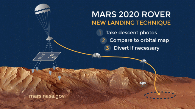
edit 1: I believe the Mars 2020 Rover landing technique has been discussed in an answer or question here, but I can't find it right now. Here's a quick link, Spaceflight Insider.
enter image description here


A spacecraft in Earth orbit can indeed determine its own position relative to the Earth's center (to several kilometers, not "exactly") using terminator and star images, and a clock that measures elapsed time. I'll just answer the conceptual aspect of your question, assuming your spacecraft has modern electronics, imaging and computing (say a really nice, "price is no object" 3U cubesat) but you don't have a ground link to send location data to it from Earth, nor have GPS.

If you have several fixes spaced around the Earth's terminator, and knowledge of the shape of the Earth, you can indeed get the distance from the Earth and the direction of the Earth's center. Since the atmosphere has say 5 km of "noise" (clouds) it won't be perfect, but a given measurement should be reliable to about 1 part per thousand in distance.

Combine the vector (direction plus distance) towards the Earth's center with the spacecraft's attitude with respect to the stars using two star camera fixes (direction-only of course), and you can determine your 3D location in space with respect to the Earth's geometrical center to that 1 part per thousand; 7km in LEO or 40 km in GEO for example.

However keep making these measurements for a period of time of one orbit, and you have measured your distance much more precisely using a Keplerian (or better) model and the known mass of the Earth and tightened up the uncertainty substantially. (The more you sample the terminator, the more the clouds will tend to average out as well.) This just relies on your clock giving you elapsed time between measurements, not necessarily absolute time and date.

As soon as you are measuring for roughly the period of an orbit, you only need the direction to the center of the Earth, not the size. As the Earth's direction with respect to the stars is tracked and timestamped, you can fit it with a model for all of the orbital parameters, eccentricity, inclination, nodes, etc.

This all assumes you have well-calibrated cameras and the orientations of each camera's field of view with respect to all other cameras is known, or can be cross-calibrated in real time - depending how the spacecraft rotates and how dedicated vs flexible each camera is. It also assumes the cameras are built well to handle star or terminator imaging, don't get burned out by the Sun (star cameras often/usually have safety shutters), and you can manage your spacecraft's rotation (attitude) sufficiently to make sure the right cameras point at the right things.

Having fixes on the Sun and Moon will help you calculate the Earth's position relative position within the solar system barycenter if you need that. Of course if you have an ephemeris and your clock knows the actual time and date, you can have that already.

$\endgroup$
2
  • 1
    $\begingroup$ Do you think a system like this would be more accurate if orbiting something that either has no atmosphere or has a very limited one such as a moon or mars? Also, what do you think about using feature recognition to increase your fix relative to the body being orbited (Similar to the experiment referenced by @Ohsin) and what's the bottleneck to determining location accuracy (sensor resolution?) $\endgroup$
    – Dragongeek
    Commented Nov 4, 2017 at 12:03
  • 1
    $\begingroup$ @Dragongeek potentially, yes, but there are plenty of instrumental issues and computational issues. The harder you push the image analysis, the more computing power you need, (power, heat management) and the more precisely and frequently you'll need to calibrate and cross-calibrate the various imaging systems. Precision optical systems are sensitive even to small changes in temperature in a laboratory environment, but in a spacecraft temperatures can vary wildly. $\endgroup$
    – uhoh
    Commented Nov 4, 2017 at 13:46

Your Answer

By clicking “Post Your Answer”, you agree to our terms of service and acknowledge you have read our privacy policy.

Not the answer you're looking for? Browse other questions tagged or ask your own question.