10
$\begingroup$

Could Apollo's Sextant navigation for Cislunar Celestial Navigation use similar geometry as Marine Navigation?

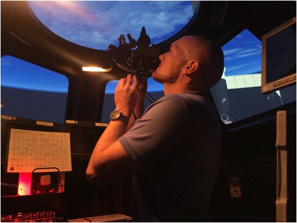
My grandfather would be familiar with the instrument in this astronaut’s hands, although he would be puzzled by the view out the window.

enter image description here

There are numerous internet references to Apollo spacecraft using a sextant for cislunar celestial position fixes but I’m unable to find an explanation of the geometric method used.

The sextant on Apollo had 3 functions:

  1. Attitude measurement using star sights. This was used to correct drift in the Inertial Measurement Unit (IMU) utilizing programs P51 and P52 https://web.mit.edu/digitalapollo/Documents/Chapter6/hoagprogreport.pdf . This is analogous to aircraft zeroing their gyrocompass on their runway heading before take off.
  2. Orbital fixes while in low Earth and Lunar orbits, using known surface landmarks. This is analogous to Marine Coastal Piloting, which uses previously surveyed shore landmarks.
  3. Celestial fixes during Cislunar Navigation. This used star and horizon sights, along with the Apollo P23 program. It is this Cislunar Navigation which I am puzzling over. It is analogous to offshore Celestial Marine Navigation.

Offshore Marine Celestial Navigation uses the horizon as a horizontal reference plane with which to measure the angular altitude of a celestial body. This provides a circle of position on the Earth (and celestial sphere). Three or more circles from different celestial bodies will provide intersecting circles of position, giving a fix.

enter image description here

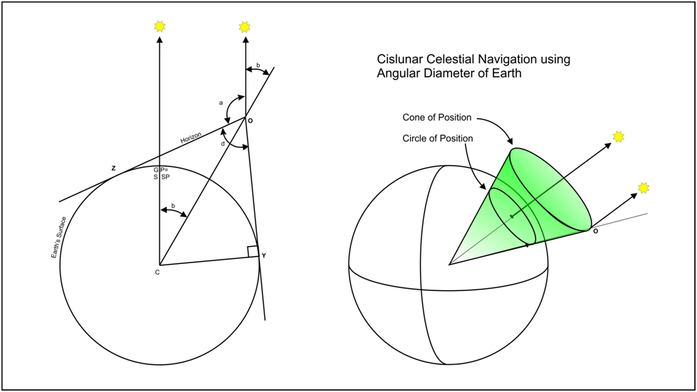
This method will not work in a spacecraft. The horizon will no longer provide a planar reference surface, but instead a conical reference. (Aircraft sextants dodge the absent horizon problem by using an internal artificial horizon. But a bubble-type artificial horizon will not work in free fall.)

Sighting on the visible horizon from space provides a “cone of position”. The apex of the cone is at an unknown altitude. Three such cones from observation of three different celestial bodies could give a 3D fix if you have computer program clever enough to figure out the conic intersections.

enter image description here

Another possible method is to go back to traditional marine celestial navigation by obtaining three circles of position. A sight on the Earth’s diameter would give the altitude of the observer. It would also allow the apparent angular altitude of the celestial body “a” to derive “b”.

enter image description here

In the sketch, “a” and “d” would be measured. Since the radius of the earth and all angles are known, the observer’s altitude can be calculated. Three celestial observations give three intersecting circles of position on the celestial sphere. This can be translated into geographic position if desired.

Sextants (including the ones on Apollo) are calibrated to 10 seconds of arc. Lunar diameter measurements could approach this accuracy, but Earth diameter measurements would be hampered by the “fuzzy edge” of the atmosphere. In Apollo 8, Jim Lovell was “remarkably consistent” in his choice of apparent horizon altitude. But he was using a single sunlit horizon and a star, not one sunlit and one night time horizon (which would often be necessary to measure earth diameter).

Does anyone know what geometric method was used for cislunar celestial navigation in Apollo? Anyone think my Grampa’s Marine Celestial navigation could be used in space (with addition of Planetary Diameters) ?
$\endgroup$
2

2 Answers 2

4
$\begingroup$

Since I didn't have 50 rep points yet I've posted this as a partial answer. My research came up with the following from (for example) GIS Wiki's Sextant (similar wording in Celestial Navitagion Information Network's How to use a Sextant and also here):

Held horizontally, the sextant can be used to measure the angle between any two objects, such as between two lighthouses, which will, similarly, allow for calculation of a line of position on a chart. Celestial navigation continues to be used by private yachtsmen, and particularly by long-distance cruising yachts around the world.

$\endgroup$
3
  • 2
    $\begingroup$ Yes. Horizontal sextant angles are used for Coastal Piloting. Yes, offshore celestial navigation still works as well as it did a century ago. Apparently it works in space as well. I'm looking for the geometric method used by the Apollo Program. $\endgroup$
    – Woody
    Commented Nov 30, 2021 at 19:03
  • $\begingroup$ I think they used a form of gyroscope... I am not 100% sure $\endgroup$
    – Jackson
    Commented Nov 30, 2021 at 19:07
  • $\begingroup$ I added a link to some possible sourced for your quote. We block quote from sources all the time here but Stack Exchange and good practice require us to cite the original source of the information when using it. $\endgroup$
    – uhoh
    Commented Dec 1, 2021 at 22:31
0
$\begingroup$

Question “What geometric method was used for Apollo Cislunar navigation? Answer: There was not a single geometric method. Sextant sights were reduced to lines of position, not discrete position fixes. Multiple navigational inputs were numerically integrated by the Flight Computer (FC) to continuously update the State Vector.

Question: “Could traditional Marine Celestial Navigation be used for Cislunar navigation?” Answer: Maybe. But hand calculations would be so tedious the answers would likely be irrelevant by the time they appeared. Calculations could be sped up with a computer, but it would still provide only a position fix, not a vector. The State Vector could be derived from multiple fixes, but once again the information would be stale before it arrived.

Cislunar navigation on Apollo was dependent on either the Command Module’s FC or ground based computing. It could not have been accomplished by hand calculations and ephemeris.

• The following is excerpted from The Apollo Guidance and Navigation document R-500 from MIT https://ntrs.nasa.gov/api/citations/19660019469/downloads/19660019469.pdf

“The originally stated premise that a single failure should leave the system with enough capability to return safely should now be examined... If ground tracking navigation data are unavailable because of a loss of communications, then the onboard system can perform all the necessary navigation. If the onboard navigation capability fails, the ground can provide the necessary data. This applies to the failure of either the optics system or the onboard computer.”

A computer is always in the loop. It can do a better, faster job than traditional methods.

From Chapter III-2 Coasting Flight Navigation: (same document)

Flight Computer (FC) Inputs:

Distance, velocity, elevation and azimuth from well-established reference points
Angles between lines of sight to known celestial objects,
Star occultations, and
Apparent planet diameters.

The input navigation information listed above does not include an absolute position fix, but each piece of information can update a portion of the State Vector coordinates. For instance, radar may provide z-axis data and velocity. Horizon/star sights may provide x-axis and y-axis data but no velocity data.

A value for the 6-dimensional State Vector is maintained in the FC. It uses an Earth- or Moon-centered equatorial coordinate system (depending on the sphere of influence). The computer uses equations of motion to continuously update the State Vector using numerical integration of the inertial sensor data. As other navigational inputs become available, they, too, are used to update the State Vector.

During cislunar flight, navigation observations could potentially keep astronauts busy 24/7 … too busy to perform other tasks. To optimize the workload, the flight plan limits navigation observations to those which will increase navigational accuracy. Accuracy was defined as reduced RMS error at the next transit endpoint, such as Lunar orbital insertion.

$\endgroup$

Your Answer

By clicking “Post Your Answer”, you agree to our terms of service and acknowledge you have read our privacy policy.

Not the answer you're looking for? Browse other questions tagged or ask your own question.